
Doe een donatie
Rust jezelf uit voor je volgende avontuur:
Als Amazon-partner verdient deze site een commissie op in aanmerking komende aankopen, zonder extra kosten voor jou.
Topografische kaart Manhattan Island
Klik op de kaart om de hoogte weer te geven.
Doe een donatie
Rust jezelf uit voor je volgende avontuur:
Als Amazon-partner verdient deze site een commissie op in aanmerking komende aankopen, zonder extra kosten voor jou.
Manhattan Island
Parkland covers a total of 2,659 acres (10.76 km2), accounting for 18.2% of the borough's land area; the 840-acre (3.4 km2) Central Park is the borough's largest park, comprising 31.6% of Manhattan's parkland. Designed by Frederick Law Olmsted and Calvert Vaux, the park is anchored by the 12-acre (4.9 ha) Great Lawn and offers extensive walking tracks, two ice-skating rinks, a wildlife sanctuary, and several lawns and sporting areas, as well as 21 playgrounds, and a 6-mile (9.7 km) road from which automobile traffic has been banned since 2018. While much of the park looks natural, it is almost entirely landscaped; the construction of Central Park in the 1850s was one of the era's most massive public works projects, with some 20,000 workers moving 5 million cubic yards (3.8 million cubic meters) of material to shape the topography and create the English-style pastoral landscape that Olmsted and Vaux sought.
Doe een donatie
Rust jezelf uit voor je volgende avontuur:
Als Amazon-partner verdient deze site een commissie op in aanmerking komende aankopen, zonder extra kosten voor jou.
Over deze kaart
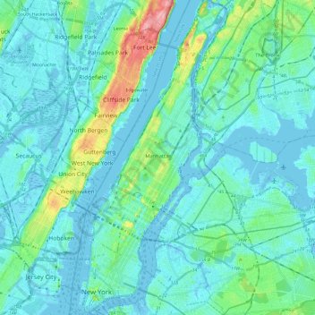
Naam: Topografische kaart Manhattan Island, hoogte, reliëf.
Locatie: Manhattan Island, New York, United States (40.69978 -74.01934 40.87762 -73.91044)
Gemiddelde hoogte: 17 m
Minimale hoogte: -11 m
Maximale hoogte: 117 m
Doe een donatie
Rust jezelf uit voor je volgende avontuur:
Als Amazon-partner verdient deze site een commissie op in aanmerking komende aankopen, zonder extra kosten voor jou.