
Topografische kaart Toronto
Interactieve kaart
Klik op de kaart om de hoogte weer te geven.
Over deze kaart
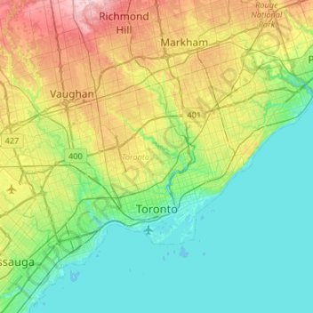
Naam: Topografische kaart Toronto, hoogte, reliëf.
Locatie: Toronto, Peel, Golden Horseshoe, Ontario, Canada (43.58025 -79.63927 43.85544 -79.11322)
Gemiddelde hoogte: 140 m
Minimale hoogte: 69 m
Maximale hoogte: 332 m
Despite its deep ravines, Toronto is not remarkably hilly, but its elevation does increase steadily away from the lake. Elevation differences range from 76.5 metres (251 ft) above sea level at the Lake Ontario shore to 209 m (686 ft) ASL near the York University grounds in the city's north end at the intersection of Keele Street and Steeles Avenue. There are occasional hilly areas; in particular, midtown Toronto has a number of sharply sloping hills. Lake Ontario remains occasionally visible from the peaks of these ridges as far north as Eglinton Avenue, 7 to 8 kilometres (4.3 to 5.0 mi) inland.