
Topografische kaart Rio Grande
Interactieve kaart
Klik op de kaart om de hoogte weer te geven.
Rio Grande
The Rio Grande rises in high mountains and flows for much of its length at high elevation; Albuquerque is 5,312 feet (1,619 m), and El Paso 3,762 feet (1,147 m) above sea level. In New Mexico, the river flows through the Rio Grande rift from one sediment-filled basin to another, cutting canyons between the basins and supporting a fragile bosque ecosystem on its flood plain. From El Paso eastward, the river flows through desert. Although irrigated agriculture exists throughout most of its stretch, it is particularly extensive in the subtropical Lower Rio Grande Valley. The river ends in a small, sandy delta at the Gulf of Mexico. During portions of 2001 and 2002, the mouth of the Rio Grande was blocked by a sandbar. In the fall of 2003, the sandbar was cleared by high river flows around 7,063 cubic feet per second (200 m3/s).
Over deze kaart
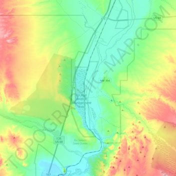
Naam: Topografische kaart Rio Grande, hoogte, reliëf.
Locatie: Rio Grande, Socorro County, New Mexico, United States (34.25482 -106.88750 34.43727 -106.79837)
Gemiddelde hoogte: 1.502 m
Minimale hoogte: 1.419 m
Maximale hoogte: 1.652 m
Andere topografische kaarten
Klik op een kaart om zijn topografie, zijn hoogte en zijn reliëf te bekijken.