
Topografische kaart Lewis County
Interactieve kaart
Klik op de kaart om de hoogte weer te geven.
Over deze kaart
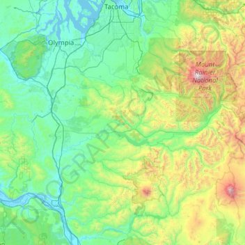
Naam: Topografische kaart Lewis County, hoogte, reliëf.
Locatie: Lewis County, Washington, United States of America (46.38127 -123.37090 46.79445 -121.35268)
Gemiddelde hoogte: 558 m
Minimale hoogte: -3 m
Maximale hoogte: 4.320 m
Andere topografische kaarten
Klik op een kaart om zijn topografie, zijn hoogte en zijn reliëf te bekijken.
Danville
United States of America > Washington > Maple Valley > Danville
Danville, Maple Valley, King County, Washington, 98038, United States of America
Gemiddelde hoogte: 174 m
Skamania County
United States of America > Washington
Skamania County, Washington, United States of America
Gemiddelde hoogte: 771 m
Clallam County
United States of America > Washington
Clallam County, Washington, United States of America
Gemiddelde hoogte: 335 m
Anacortes
United States of America > Washington > Anacortes
Anacortes, Skagit County, Washington, United States of America
Gemiddelde hoogte: 36 m
Spokane County
United States of America > Washington
Spokane County, Washington, United States of America
Gemiddelde hoogte: 741 m
Okanogan County
United States of America > Washington
Okanogan County, Washington, United States of America
Gemiddelde hoogte: 1.076 m
Yakima County
United States of America > Washington
Yakima County, Washington, United States of America
Gemiddelde hoogte: 879 m
Spokane
United States of America > Washington > Spokane
Spokane, Spokane County, Washington, United States of America
Gemiddelde hoogte: 654 m
Pacific County
United States of America > Washington
Pacific County, Washington, United States of America
Gemiddelde hoogte: 124 m