
Topografische kaart Pickens County
Interactieve kaart
Klik op de kaart om de hoogte weer te geven.
Over deze kaart
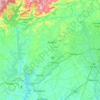
Naam: Topografische kaart Pickens County, hoogte, reliëf.
Locatie: Pickens County, South Carolina, United States of America (34.62031 -82.94366 35.08594 -82.47646)
Gemiddelde hoogte: 327 m
Minimale hoogte: 188 m
Maximale hoogte: 1.125 m
According to the U.S. Census Bureau, the county has a total area of 512 square miles (1,330 km2), of which 496 square miles (1,280 km2) is land and 16 square miles (41 km2) (3.1%) is water. The county also contains the highest natural point in South Carolina, Sassafras Mountain, with an elevation of 3560 feet (1085 m). Table Rock State Park (South Carolina) is in Pickens County.
Andere topografische kaarten
Klik op een kaart om zijn topografie, zijn hoogte en zijn reliëf te bekijken.
Broad River Bluff
United States of America > South Carolina > Broad River Bluff
Broad River Bluff, Beaufort County, South Carolina, 29906, United States of America
Gemiddelde hoogte: 5 m
Croft State Park
United States of America > South Carolina > Ponderosa Gardens
Croft State Park, Ponderosa Gardens, Spartanburg County, South Carolina, United States of America
Gemiddelde hoogte: 207 m
Dawkins
United States of America > South Carolina > Dawkins
Dawkins, Fairfield County, South Carolina, United States of America
Gemiddelde hoogte: 104 m
Twelve Mile Creek
United States of America > South Carolina
Twelve Mile Creek, Lancaster County, South Carolina, 28173, United States of America
Gemiddelde hoogte: 162 m
Gaffney
United States of America > South Carolina > Gaffney
Gaffney, Cherokee County, South Carolina, 29342, United States of America
Gemiddelde hoogte: 219 m
Eau Claire
United States of America > South Carolina > Columbia > Eau Claire
Eau Claire, Columbia, Richland County, South Carolina, 29220, United States of America
Gemiddelde hoogte: 81 m
Hammond
United States of America > South Carolina > Hammond
Hammond, Horry County, South Carolina, United States of America
Gemiddelde hoogte: 8 m
Fingerville
United States of America > South Carolina > Fingerville
Fingerville, Spartanburg County, South Carolina, 29338, United States of America
Gemiddelde hoogte: 261 m