
Topografische kaart Cullman
Interactieve kaart
Klik op de kaart om de hoogte weer te geven.
Over deze kaart
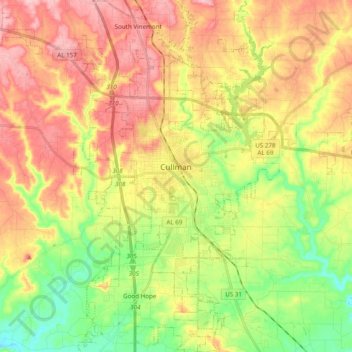
Naam: Topografische kaart Cullman, hoogte, reliëf.
Locatie: Cullman, Cullman County, Alabama, United States (34.09015 -86.90025 34.25071 -86.77715)
Gemiddelde hoogte: 239 m
Minimale hoogte: 159 m
Maximale hoogte: 321 m
Cullman is located on top of the Brindley Mountain plateau at 34°10′39″N 86°50′42″W / 34.17750°N 86.84500°W / 34.17750; -86.84500 (34.177508, −86.844996). This is a close offshoot of the long geographic ridge called Sand Mountain, a southmost extension of the Appalachian Mountains. The elevation is 826 feet (252 m), close to the watershed between the Tennessee River and the Black Warrior River. Cullman provides its own town water supply from a city-owned lake within the city limits, Lake Catoma.
Andere topografische kaarten
Klik op een kaart om zijn topografie, zijn hoogte en zijn reliëf te bekijken.
Trade
United States > Alabama > Cullman County
Trade, Cullman County, Alabama, 35053, United States
Gemiddelde hoogte: 210 m
Fairview
United States > Alabama > Cullman County
Fairview, Cullman County, Alabama, United States
Gemiddelde hoogte: 281 m
West Point
United States > Alabama > Cullman County
West Point, Cullman County, Alabama, United States
Gemiddelde hoogte: 284 m
Joppa
United States > Alabama > Cullman County
Joppa, Cullman County, Alabama, 35087, United States
Gemiddelde hoogte: 308 m
Dodge City
United States > Alabama > Cullman County
Dodge City, Cullman County, Alabama, United States
Gemiddelde hoogte: 192 m
Baileyton
United States > Alabama > Cullman County
Baileyton, Cullman County, Alabama, United States
Gemiddelde hoogte: 295 m
Colony
United States > Alabama > Cullman County
Colony, Cullman County, Alabama, United States
Gemiddelde hoogte: 142 m
East Point
United States > Alabama > Cullman County
East Point, Cullman County, Alabama, 35055, United States
Gemiddelde hoogte: 230 m
Birdsong
United States > Alabama > Cullman County
Birdsong, Cullman County, Alabama, 35019, United States
Gemiddelde hoogte: 267 m
Arkadelphia
United States > Alabama > Cullman County
Arkadelphia, Cullman County, Alabama, United States
Gemiddelde hoogte: 129 m
Holly Pond
United States > Alabama > Cullman County
Holly Pond, Cullman County, Alabama, United States
Gemiddelde hoogte: 249 m
Black Bottom
United States > Alabama > Cullman County
Black Bottom, Cullman County, Alabama, United States
Gemiddelde hoogte: 116 m
Vinemont
United States > Alabama > Cullman County > South Vinemont
Vinemont, South Vinemont, Cullman County, Alabama, 35056, United States
Gemiddelde hoogte: 289 m
Good Hope
United States > Alabama > Cullman County
Good Hope, Cullman County, Alabama, United States
Gemiddelde hoogte: 210 m
Bremen
United States > Alabama > Cullman County
Bremen, Cullman County, Alabama, United States
Gemiddelde hoogte: 199 m
Berlin
United States > Alabama > Cullman County
Berlin, Cullman County, Alabama, United States
Gemiddelde hoogte: 250 m
South Vinemont
United States > Alabama > Cullman County
South Vinemont, Cullman County, Alabama, United States
Gemiddelde hoogte: 287 m
Battleground
United States > Alabama > Cullman County
Battleground, Cullman County, Alabama, United States
Gemiddelde hoogte: 302 m
Logan
United States > Alabama > Cullman County
Logan, Cullman County, Alabama, 35098, United States
Gemiddelde hoogte: 240 m
Garden City
United States > Alabama > Cullman County
Garden City, Cullman County, Alabama, 35070, United States
Gemiddelde hoogte: 177 m
Crane Hill
United States > Alabama > Cullman County
Crane Hill, Cullman County, Alabama, 35098, United States
Gemiddelde hoogte: 215 m
Providence
United States > Alabama > Cullman County
Providence, Cullman County, Alabama, United States
Gemiddelde hoogte: 284 m
Hanceville
United States > Alabama > Cullman County
Hanceville, Cullman County, Alabama, United States
Gemiddelde hoogte: 177 m
Good Hope
United States > Alabama > Cullman County > Good Hope
Good Hope, Cullman County, Alabama, United States
Gemiddelde hoogte: 210 m