
Topografische kaart La Mouche
Interactieve kaart
Klik op de kaart om de hoogte weer te geven.
Over deze kaart
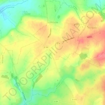
Naam: Topografische kaart La Mouche, hoogte, reliëf.
Gemiddelde hoogte: 127 m
Minimale hoogte: 86 m
Maximale hoogte: 162 m
Andere topografische kaarten
Klik op een kaart om zijn topografie, zijn hoogte en zijn reliëf te bekijken.
Tourville-sur-Sienne
Tourville-sur-Sienne, Coutances, Manche, Normandie, France métropolitaine, 50200, France
Gemiddelde hoogte: 38 m
Marigny-Le-Lozon
Marigny-Le-Lozon, Saint-Lô, Manche, Normandie, France métropolitaine, 50570, France
Gemiddelde hoogte: 61 m
La Fossairie
France > Normandie > Manche > Marigny-Le-Lozon > Marigny
La Fossairie, Marigny, Marigny-Le-Lozon, Saint-Lô, Manche, Normandie, France métropolitaine, 50570, France
Gemiddelde hoogte: 63 m
Longueville
Longueville, Avranches, Manche, Normandie, France métropolitaine, 50290, France
Gemiddelde hoogte: 38 m
Villedieu-les-Poêles
France > Normandie > Manche > Villedieu-les-Poêles-Rouffigny
Villedieu-les-Poêles, Villedieu-les-Poêles-Rouffigny, Saint-Lô, Manche, Normandie, France métropolitaine, 50800, France
Gemiddelde hoogte: 161 m
La Chapelle-en-Juger
La Chapelle-en-Juger, Thèreval, Saint-Lô, Manche, Normandie, France métropolitaine, 50570, France
Gemiddelde hoogte: 62 m
Coudeville
France > Normandie > Manche > Saint-Martin-d'Aubigny
Coudeville, Saint-Martin-d'Aubigny, Coutances, Manche, Normandie, France métropolitaine, 50190, France
Gemiddelde hoogte: 36 m
Coudeville-sur-Mer
Coudeville-sur-Mer, Avranches, Manche, Normandie, France métropolitaine, 50290, France
Gemiddelde hoogte: 42 m
La Haute Forière
France > Normandie > Manche > Le Parc
La Haute Forière, Sainte-Pience, Le Parc, Avranches, Manche, Normandie, France métropolitaine, 50870, France
Gemiddelde hoogte: 167 m
Les Masses
France > Normandie > Manche > Morsalines
Les Masses, Morsalines, Quettehou, Cherbourg, Manche, Normandie, France métropolitaine, 50630, France
Gemiddelde hoogte: 46 m
Saint-Germain-sur-Ay
Saint-Germain-sur-Ay, Coutances, Manche, Normandie, France métropolitaine, 50430, France
Gemiddelde hoogte: 12 m
Chevry
France > Normandie > Manche > Moyon Villages
Chevry, Moyon Villages, Saint-Lô, Manche, Normandie, France métropolitaine, 50420, France
Gemiddelde hoogte: 103 m
Gofontaine
France > Normandie > Manche > Tocqueville
Gofontaine, Tocqueville, Cherbourg, Manche, Normandie, France métropolitaine, 50330, France
Gemiddelde hoogte: 54 m
Vergoncey
France > Normandie > Manche > Saint-James
Vergoncey, Saint-James, Avranches, Manche, Normandie, France métropolitaine, 50240, France
Gemiddelde hoogte: 52 m
Clairefontaine
France > Normandie > Manche > Siouville-Hague
Clairefontaine, Siouville-Hague, Cherbourg, Manche, Normandie, France métropolitaine, 50340, France
Gemiddelde hoogte: 34 m
Coulouvray-Boisbenâtre
France > Normandie > Manche > Coulouvray-Boisbenâtre
Coulouvray-Boisbenâtre, Avranches, Manche, Normandie, France métropolitaine, 50670, France
Gemiddelde hoogte: 223 m
Sainte-Cécile
Sainte-Cécile, Saint-Lô, Manche, Normandie, France métropolitaine, 50800, France
Gemiddelde hoogte: 161 m
Orval
France > Normandie > Manche > Orval-sur-Sienne
Orval, Orval-sur-Sienne, Coutances, Manche, Normandie, France métropolitaine, 50660, France
Gemiddelde hoogte: 36 m
Le Mont-Saint-Michel
Le Mont-Saint-Michel, Avranches, Manche, Normandie, France métropolitaine, 50170, France
Gemiddelde hoogte: 5 m
Cherbourg-en-Cotentin
Cherbourg-en-Cotentin, Cherbourg, Manche, Normandie, France métropolitaine, France
Gemiddelde hoogte: 67 m
Jullouville
Jullouville, Avranches, Manche, Normandie, France métropolitaine, 50610, France
Gemiddelde hoogte: 29 m
Saint-Vaast-la-Hougue
Saint-Vaast-la-Hougue, Cherbourg, Manche, Normandie, France métropolitaine, 50550, France
Gemiddelde hoogte: 3 m