
Topografische kaart Story County
Interactieve kaart
Klik op de kaart om de hoogte weer te geven.
Over deze kaart
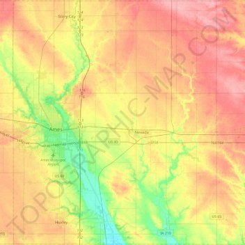
Naam: Topografische kaart Story County, hoogte, reliëf.
Locatie: Story County, Iowa, United States of America (41.86279 -93.70002 42.20936 -93.23155)
Gemiddelde hoogte: 308 m
Minimale hoogte: 255 m
Maximale hoogte: 356 m
Andere topografische kaarten
Klik op een kaart om zijn topografie, zijn hoogte en zijn reliëf te bekijken.
Harpers Ferry
United States of America > Iowa > Harpers Ferry
Harpers Ferry, Allamakee County, Iowa, United States of America
Gemiddelde hoogte: 216 m
Keystone
United States of America > Iowa > Keystone
Keystone, Benton County, Iowa, 52249, United States of America
Gemiddelde hoogte: 272 m
Westgate
United States of America > Iowa > Westgate
Westgate, Iowa, United States of America
Gemiddelde hoogte: 333 m
Clarke County
United States of America > Iowa
Clarke County, Iowa, United States of America
Gemiddelde hoogte: 331 m
Fraser
United States of America > Iowa > Fraser
Fraser, Boone County, Iowa, United States of America
Gemiddelde hoogte: 307 m
Van Buren County
United States of America > Iowa
Van Buren County, Iowa, United States of America
Gemiddelde hoogte: 217 m
Woodbury County
United States of America > Iowa
Woodbury County, Iowa, United States of America
Gemiddelde hoogte: 376 m
Iowa County
United States of America > Iowa
Iowa County, Iowa, United States of America
Gemiddelde hoogte: 249 m
Evander
United States of America > Iowa > Evander
Evander, O'Brien County, Iowa, United States of America
Gemiddelde hoogte: 433 m
Iowa City
United States of America > Iowa > Iowa City
Iowa City, Johnson County, Iowa, United States of America
Gemiddelde hoogte: 216 m