
Topografische kaart Lair
Interactieve kaart
Klik op de kaart om de hoogte weer te geven.
Over deze kaart
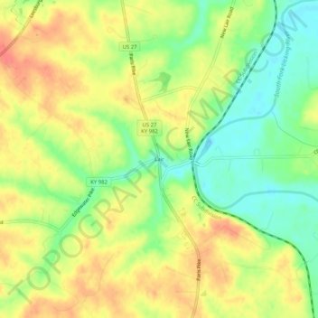
Naam: Topografische kaart Lair, hoogte, reliëf.
Locatie: Lair, Harrison County, Kentucky, 41031, United States (38.32202 -84.32771 38.36202 -84.28771)
Gemiddelde hoogte: 246 m
Minimale hoogte: 216 m
Maximale hoogte: 273 m
Andere topografische kaarten
Klik op een kaart om zijn topografie, zijn hoogte en zijn reliëf te bekijken.
Boyd
United States > Kentucky > Harrison County
Boyd, Harrison County, Kentucky, 41003, United States
Gemiddelde hoogte: 214 m
Leesburg
United States > Kentucky > Harrison County
Leesburg, Harrison County, Kentucky, United States
Gemiddelde hoogte: 280 m
Broadwell
United States > Kentucky > Harrison County
Broadwell, Harrison County, Kentucky, United States
Gemiddelde hoogte: 264 m
Berry
United States > Kentucky > Harrison County
Berry, Harrison County, Kentucky, 41003, United States
Gemiddelde hoogte: 211 m
Connersville
United States > Kentucky > Harrison County
Connersville, Harrison County, Kentucky, United States
Gemiddelde hoogte: 256 m
Lees Lick
United States > Kentucky > Harrison County
Lees Lick, Harrison County, Kentucky, United States
Gemiddelde hoogte: 265 m
Rutland
United States > Kentucky > Harrison County
Rutland, Harrison County, Kentucky, United States
Gemiddelde hoogte: 256 m
Buena Vista
United States > Kentucky > Harrison County
Buena Vista, Harrison County, Kentucky, United States
Gemiddelde hoogte: 247 m
Claysville
United States > Kentucky > Harrison County
Claysville, Harrison County, Kentucky, United States
Gemiddelde hoogte: 209 m
Colemansville
United States > Kentucky > Harrison County
Colemansville, Harrison County, Kentucky, 41003, United States
Gemiddelde hoogte: 217 m
Antioch
United States > Kentucky > Harrison County
Antioch, Harrison County, Kentucky, United States
Gemiddelde hoogte: 233 m
Colville
United States > Kentucky > Harrison County
Colville, Harrison County, Kentucky, United States
Gemiddelde hoogte: 266 m
Robinson
United States > Kentucky > Harrison County
Robinson, Harrison County, Kentucky, 41003, United States
Gemiddelde hoogte: 221 m
Oddville
United States > Kentucky > Harrison County
Oddville, Harrison County, Kentucky, United States
Gemiddelde hoogte: 258 m
Kelat
United States > Kentucky > Harrison County
Kelat, Harrison County, Kentucky, United States
Gemiddelde hoogte: 256 m
Cynthiana
United States > Kentucky > Harrison County
Cynthiana, Harrison County, Kentucky, 41031, United States
Gemiddelde hoogte: 238 m