
Topografische kaart Sturgeon Falls
Klik op de kaart om de hoogte weer te geven.
Over deze kaart
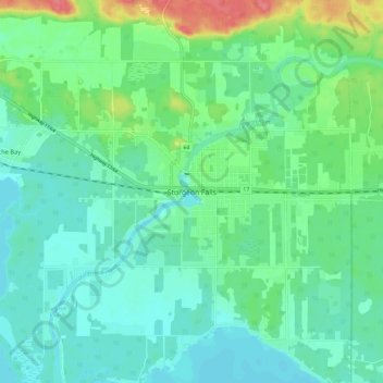
Naam: Topografische kaart Sturgeon Falls, hoogte, reliëf.
Gemiddelde hoogte: 209 m
Minimale hoogte: 191 m
Maximale hoogte: 261 m
Andere topografische kaarten
Klik op een kaart om zijn topografie, zijn hoogte en zijn reliëf te bekijken.
North Bay
Canada > Ontario > Nipissing District
The climate in North Bay is common to most places in Northern Ontario. North Bay tends to be a less humid climate than that found in Southern Ontario due somewhat to the distance from the Great Lakes and less warm than some other locations in Northern Ontario due to cooling from Lake Nipissing. On May 31,…
Gemiddelde hoogte: 266 m
Lake Nipissing
Canada > Ontario > Nipissing District
Lake Nipissing (/ˈnɪpəsɪŋ/; French: lac Nipissing, Ojibwe: Gichi-nibiinsing-zaaga’igan) is a lake in the Canadian province of Ontario. It has a surface area of 873.3 km2 (337.2 sq mi), a mean elevation of 196 m (643 ft) above sea level, and is located between the Ottawa River and Georgian Bay. Lake…
Gemiddelde hoogte: 272 m
Bissett Lake
Canada > Ontario > Nipissing District > Unorganized South Nipissing
Gemiddelde hoogte: 367 m
Victoria Lake
Canada > Ontario > Nipissing District > South Algonquin Township
Gemiddelde hoogte: 407 m
Smoke Lake
Canada > Ontario > Nipissing District > Unorganized South Nipissing
Gemiddelde hoogte: 439 m
Kawawaymog Lake
Canada > Ontario > Nipissing District > Unorganized South Nipissing
Gemiddelde hoogte: 385 m
Guthrie Lake
Canada > Ontario > Nipissing District > Unorganized South Nipissing
Gemiddelde hoogte: 299 m
Rowan Lake
Canada > Ontario > Nipissing District > Unorganized South Nipissing
Gemiddelde hoogte: 281 m
Arrow Lake
Canada > Ontario > Nipissing District > Unorganized South Nipissing
Gemiddelde hoogte: 414 m
Temagami
Canada > Ontario > Nipissing District
Temagami provides rugged topography, which is excellent for canoeing and hiking. There are numerous viewpoints in the municipality, including High Rock and Caribou Mountain, which contains a 100 ft (30 m) fire tower on its summit.
Gemiddelde hoogte: 319 m
Crotch Lake
Canada > Ontario > Nipissing District > Unorganized South Nipissing
Gemiddelde hoogte: 414 m
Princes Lake
Canada > Ontario > Nipissing District > South Algonquin Township
Gemiddelde hoogte: 467 m
Ralph Bice Lake
Canada > Ontario > Nipissing District > Unorganized South Nipissing
Gemiddelde hoogte: 464 m
Wenona Lake
Canada > Ontario > Nipissing District > Unorganized South Nipissing
Gemiddelde hoogte: 467 m
Papineau Lake
Canada > Ontario > Nipissing District > Papineau-Cameron Township
Gemiddelde hoogte: 334 m
Rose Lake
Canada > Ontario > Nipissing District > Unorganized South Nipissing
Gemiddelde hoogte: 459 m
Cedar Lake
Canada > Ontario > Nipissing District > Unorganized South Nipissing
Gemiddelde hoogte: 370 m
Carcajou Lake
Canada > Ontario > Nipissing District > Unorganized South Nipissing
Gemiddelde hoogte: 291 m
Gilmour Lake
Canada > Ontario > Nipissing District > Papineau-Cameron Township
Gemiddelde hoogte: 342 m
William Lake
Canada > Ontario > Nipissing District > Unorganized South Nipissing
Gemiddelde hoogte: 421 m
Moccasin Lake
Canada > Ontario > Nipissing District > Unorganized South Nipissing
Gemiddelde hoogte: 465 m
Sunday Lake
Canada > Ontario > Nipissing District > Unorganized South Nipissing
Gemiddelde hoogte: 464 m
Biggar Lake
Canada > Ontario > Nipissing District > Unorganized South Nipissing
Gemiddelde hoogte: 409 m
Mizzy Lake
Canada > Ontario > Nipissing District > Unorganized South Nipissing
Gemiddelde hoogte: 459 m
Whitelily Lake
Canada > Ontario > Nipissing District > South Algonquin Township
Gemiddelde hoogte: 389 m
Gilmour Island
Canada > Ontario > Nipissing District > Unorganized South Nipissing
Gemiddelde hoogte: 339 m
Coldspring Lake
Canada > Ontario > Nipissing District > Unorganized South Nipissing
Gemiddelde hoogte: 440 m
Beau Lake
Canada > Ontario > Nipissing District > Unorganized South Nipissing
Gemiddelde hoogte: 416 m
Cedar Lake
Canada > Ontario > Nipissing District > Unorganized South Nipissing
Gemiddelde hoogte: 370 m
Windermere Lake
Canada > Ontario > Nipissing District > Unorganized South Nipissing
Gemiddelde hoogte: 355 m
Temagami
Canada > Ontario > Nipissing District
Temagami provides rugged topography, which is excellent for canoeing and hiking. There are numerous viewpoints in the municipality, including High Rock and Caribou Mountain, which contains a 100 ft (30 m) fire tower on its summit.
Gemiddelde hoogte: 319 m
North Bay
Canada > Ontario > Nipissing District
The climate in North Bay is common to most places in Northern Ontario. North Bay tends to be a less humid climate than that found in Southern Ontario due somewhat to the distance from the Great Lakes and less warm than some other locations in Northern Ontario due to cooling from Lake Nipissing. On May 31,…
Gemiddelde hoogte: 266 m
Maple Leaf Lake
Canada > Ontario > Nipissing District > Unorganized South Nipissing
Gemiddelde hoogte: 510 m
Thistle Lake
Canada > Ontario > Nipissing District > Unorganized South Nipissing
Gemiddelde hoogte: 459 m
Sheriff Pond
Canada > Ontario > Nipissing District > Unorganized South Nipissing
Gemiddelde hoogte: 456 m
Temagami
Canada > Ontario > Nipissing District
Temagami provides rugged topography, which is excellent for canoeing and hiking. There are numerous viewpoints in the municipality, including High Rock and Caribou Mountain, which contains a 100 ft (30 m) fire tower on its summit.
Gemiddelde hoogte: 319 m
Radiant Lake
Canada > Ontario > Nipissing District > Unorganized South Nipissing
Gemiddelde hoogte: 295 m
Bridle Lake
Canada > Ontario > Nipissing District > Unorganized South Nipissing
Gemiddelde hoogte: 430 m