
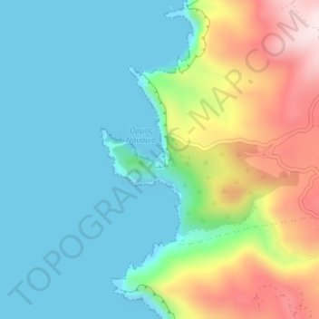
Topografische kaart Ναυάγιο
Interactieve kaart
Klik op de kaart om de hoogte weer te geven.
Over deze kaart
Naam: Topografische kaart Ναυάγιο, hoogte, reliëf.
Gemiddelde hoogte: 125 m
Minimale hoogte: -3 m
Maximale hoogte: 427 m
Andere topografische kaarten
Klik op een kaart om zijn topografie, zijn hoogte en zijn reliëf te bekijken.
Lithakia
Greece > Peloponnese, Western Greece and the Ionian > Zakynthos Regional Unit
Lithakia, Zakynthos Municipality, Zakynthos Regional Unit, Ioanian Islands, Peloponnese, Western Greece and the Ionian, 290 92, Greece
Gemiddelde hoogte: 153 m
Vardiola in Tsilivi
Greece > Peloponnese, Western Greece and the Ionian > Zakynthos Regional Unit > Planos
Vardiola in Tsilivi, Τσιβιλή - Κάτω Γερακάρι, κ. Τραγακίου, Planos, Zakynthos Municipality, Zakynthos Regional Unit, Ioanian Islands, Peloponnese, Western Greece and the Ionian, 291 00, Greece
Gemiddelde hoogte: 12 m
Zakynthos
Greece > Peloponnese, Western Greece and the Ionian > Zakynthos Regional Unit
Zakynthos, Zakynthos Regional Unit, Ioanian Islands, Peloponnese, Western Greece and the Ionian, Greece
Gemiddelde hoogte: 82 m
Kalamaki
Greece > Peloponnese, Western Greece and the Ionian > Zakynthos Regional Unit
Kalamaki, Zakynthos Municipality, Zakynthos Regional Unit, Ioanian Islands, Peloponnese, Western Greece and the Ionian, 291 00, Greece
Gemiddelde hoogte: 58 m
Alykanas
Greece > Peloponnese, Western Greece and the Ionian > Zakynthos Regional Unit
Alykanas, Zakynthos Municipality, Zakynthos Regional Unit, Ioanian Islands, Peloponnese, Western Greece and the Ionian, 290 90, Greece
Gemiddelde hoogte: 16 m
Laganas
Greece > Peloponnese, Western Greece and the Ionian > Zakynthos Regional Unit > Laganas
Laganas, Zakynthos Municipality, Zakynthos Regional Unit, Ioanian Islands, Peloponnese, Western Greece and the Ionian, 29092, Greece
Gemiddelde hoogte: 8 m