
Topografische kaart Whalley
Interactieve kaart
Klik op de kaart om de hoogte weer te geven.
Over deze kaart
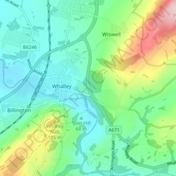
Naam: Topografische kaart Whalley, hoogte, reliëf.
Locatie: Whalley, Ribble Valley, Lancashire, England, United Kingdom (53.80241 -2.43494 53.83969 -2.37457)
Gemiddelde hoogte: 95 m
Minimale hoogte: 38 m
Maximale hoogte: 250 m
Andere topografische kaarten
Klik op een kaart om zijn topografie, zijn hoogte en zijn reliëf te bekijken.
Billington and Langho
United Kingdom > England > Lancashire > Ribble Valley > Langho
Billington and Langho, Langho, Ribble Valley, Lancashire, England, United Kingdom, Jamacia Wood
Gemiddelde hoogte: 100 m