
Topografische kaart Mannarkkad
Interactieve kaart
Klik op de kaart om de hoogte weer te geven.
Over deze kaart
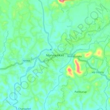
Naam: Topografische kaart Mannarkkad, hoogte, reliëf.
Gemiddelde hoogte: 80 m
Minimale hoogte: 47 m
Maximale hoogte: 201 m
Mannarkkad is located at 10°59′N 76°28′E / 10.98°N 76.47°E / 10.98; 76.47. It has an average elevation of 76 m (249 ft). Mannarkkad is located 36 km north-west of district headquarters Palakkad, along National Highway 966 and 100 km north west of Kozhikode. Mannarkkad is located in the foothills of the Western Ghats.
Andere topografische kaarten
Klik op een kaart om zijn topografie, zijn hoogte en zijn reliëf te bekijken.
Nottanmala
Nottanmala, Mannarkad, Palakkad, Kerala, 678582, India
Gemiddelde hoogte: 85 m