
Topografische kaart Damascus
Interactieve kaart
Klik op de kaart om de hoogte weer te geven.
Over deze kaart
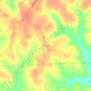
Naam: Topografische kaart Damascus, hoogte, reliëf.
Locatie: Damascus, Coffee County, Alabama, United States (31.30045 -86.02439 31.34045 -85.98439)
Gemiddelde hoogte: 102 m
Minimale hoogte: 68 m
Maximale hoogte: 121 m
Andere topografische kaarten
Klik op een kaart om zijn topografie, zijn hoogte en zijn reliëf te bekijken.
New Brockton
United States > Alabama > Coffee County
New Brockton, Coffee County, Alabama, 36351, United States
Gemiddelde hoogte: 122 m
Enterprise
United States > Alabama > Coffee County
Enterprise, Coffee County, Alabama, United States
Gemiddelde hoogte: 100 m
College Heights
United States > Alabama > Coffee County > Enterprise
College Heights, Enterprise, Coffee County, Alabama, 36331, United States
Gemiddelde hoogte: 103 m
Indian Springs
United States > Alabama > Coffee County > Enterprise > Indian Springs
Indian Springs, Enterprise, Coffee County, Alabama, 36331, United States
Gemiddelde hoogte: 96 m
Kinston
United States > Alabama > Coffee County > Kinston
Kinston, Coffee County, Alabama, 36453, United States
Gemiddelde hoogte: 72 m
Valley Hills
United States > Alabama > Coffee County > Enterprise > Valley Hills
Valley Hills, Enterprise, Coffee County, Alabama, 36330, United States
Gemiddelde hoogte: 109 m
Elba
United States > Alabama > Coffee County > Elba
Elba, Coffee County, Alabama, 36323, United States
Gemiddelde hoogte: 80 m