
Topografische kaart Ranchi
Klik op de kaart om de hoogte weer te geven.
Ranchi
Ranchi lies at 23°22′N 85°20′E / 23.36°N 85.33°E / 23.36; 85.33 near to the Tropic of Cancer. The city covers an area of 175 km2 (68 sq mi) and its average elevation is 651 m above sea level. Ranchi is located in the southern part of the Chota Nagpur plateau, which is the eastern section of the Deccan plateau.
Over deze kaart
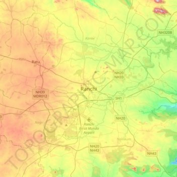
Naam: Topografische kaart Ranchi, hoogte, reliëf.
Locatie: Ranchi, Kanke, Ranchi, Jharkhand, 834001, India (23.21005 85.16504 23.53005 85.48504)
Gemiddelde hoogte: 648 m
Minimale hoogte: 458 m
Maximale hoogte: 896 m
Andere topografische kaarten
Klik op een kaart om zijn topografie, zijn hoogte en zijn reliëf te bekijken.