
Topografische kaart Sprucedale
Interactieve kaart
Klik op de kaart om de hoogte weer te geven.
Over deze kaart
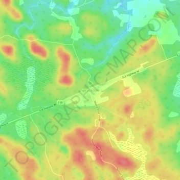
Naam: Topografische kaart Sprucedale, hoogte, reliëf.
Gemiddelde hoogte: 330 m
Minimale hoogte: 296 m
Maximale hoogte: 363 m
Andere topografische kaarten
Klik op een kaart om zijn topografie, zijn hoogte en zijn reliëf te bekijken.
Buck Lake
Canada > Ontario > Parry Sound District > McMurrich/Monteith Township
Buck Lake, McMurrich/Monteith Township, District Municipality of Muskoka, Parry Sound District, Central Ontario, Ontario, Canada
Gemiddelde hoogte: 325 m
Doe Lake
Canada > Ontario > Parry Sound District > McMurrich/Monteith Township
Doe Lake, McMurrich/Monteith Township, Parry Sound District, Central Ontario, Ontario, Canada
Gemiddelde hoogte: 303 m
Axe Lake
Canada > Ontario > Parry Sound District > McMurrich/Monteith Township
Axe Lake, McMurrich/Monteith Township, Parry Sound District, Central Ontario, Ontario, Canada
Gemiddelde hoogte: 330 m