
Topografische kaart Blancs-Coteaux
Interactieve kaart
Klik op de kaart om de hoogte weer te geven.
Over deze kaart
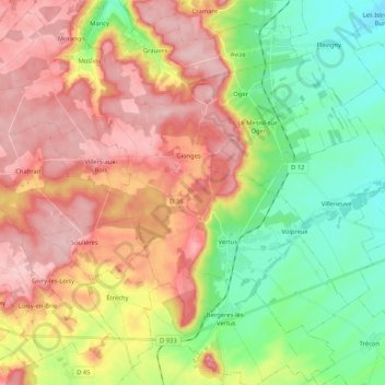
Naam: Topografische kaart Blancs-Coteaux, hoogte, reliëf.
Gemiddelde hoogte: 166 m
Minimale hoogte: 84 m
Maximale hoogte: 253 m
Andere topografische kaarten
Klik op een kaart om zijn topografie, zijn hoogte en zijn reliëf te bekijken.
Vertus
France > Grand Est > Marne > Blancs-Coteaux
Vertus, Blancs-Coteaux, Épernay, Marne, Grand Est, France métropolitaine, 51130, France
Gemiddelde hoogte: 158 m
Oger
France > Grand Est > Marne > Blancs-Coteaux
Oger, Blancs-Coteaux, Épernay, Marne, Grand Est, France métropolitaine, 51190, France
Gemiddelde hoogte: 164 m