
Topografische kaart Crandall
Interactieve kaart
Klik op de kaart om de hoogte weer te geven.
Over deze kaart
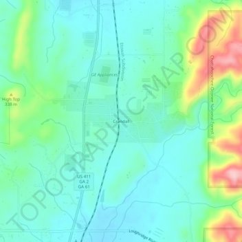
Naam: Topografische kaart Crandall, hoogte, reliëf.
Locatie: Crandall, Murray County, Georgia, 30724, United States (34.84675 -84.76549 34.88675 -84.72549)
Gemiddelde hoogte: 276 m
Minimale hoogte: 229 m
Maximale hoogte: 417 m
Andere topografische kaarten
Klik op een kaart om zijn topografie, zijn hoogte en zijn reliëf te bekijken.
Iron Mountain
United States > Georgia > Murray County
Iron Mountain, Murray County, Georgia, United States
Gemiddelde hoogte: 362 m
Cisco
United States > Georgia > Murray County
Cisco, Murray County, Georgia, 30708, United States
Gemiddelde hoogte: 293 m
Fort Mountain State Park
United States > Georgia > Murray County
Fort Mountain State Park, Murray County, Georgia, United States
Gemiddelde hoogte: 596 m
Eton
United States > Georgia > Murray County
Eton, Murray County, Georgia, 30724, United States
Gemiddelde hoogte: 236 m
Chatsworth
United States > Georgia > Murray County
Chatsworth, Murray County, Georgia, United States
Gemiddelde hoogte: 241 m