
Topografische kaart Stratford-upon-Avon
Interactieve kaart
Klik op de kaart om de hoogte weer te geven.
Over deze kaart
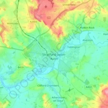
Naam: Topografische kaart Stratford-upon-Avon, hoogte, reliëf.
Gemiddelde hoogte: 61 m
Minimale hoogte: 32 m
Maximale hoogte: 129 m
Andere topografische kaarten
Klik op een kaart om zijn topografie, zijn hoogte en zijn reliëf te bekijken.
Burton Dassett Hills Country Park
Vereinigtes Königreich > England > Warwickshire > Stratford-on-Avon > Northend > Burton Dassett CP
Burton Dassett Hills Country Park, Burton Dassett CP, Northend, Stratford-on-Avon, Warwickshire, England, Vereinigtes Königreich
Gemiddelde hoogte: 132 m