
Topografische kaart Triệu Phong District
Interactieve kaart
Klik op de kaart om de hoogte weer te geven.
Over deze kaart
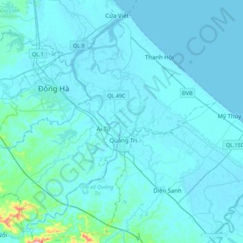
Naam: Topografische kaart Triệu Phong District, hoogte, reliëf.
Locatie: Triệu Phong District, Quang Tri province, Vietnam (16.64502 107.00015 16.90846 107.30892)
Gemiddelde hoogte: 15 m
Minimale hoogte: -3 m
Maximale hoogte: 322 m
Ái Tử Township is the economic, socio-cultural center of the district, which is 7 km south of Đông Hà City and 6 km north of Quảng Trị Town. Trieu Phong is a district consisting mainly of a coastal plain with a small number of low hills in the communes of Triệu Thượng and Triệu Ái in the west, the eastern topography of the district is sand dunes and white sand dunes. The last section of Thạch Hãn River flows to Cửa Việt estuary located in the district.
Andere topografische kaarten
Klik op een kaart om zijn topografie, zijn hoogte en zijn reliëf te bekijken.
Bến Quan
Vietnam > Quang Tri province > Vĩnh Linh District
Bến Quan, Vĩnh Linh District, Quang Tri province, Vietnam
Gemiddelde hoogte: 30 m
An Xuân
Vietnam > Quang Tri province > Gio Linh District
An Xuân, Gio Linh District, Quang Tri province, Vietnam
Gemiddelde hoogte: 10 m
Diên Sanh
Vietnam > Quang Tri province > Hải Lăng District
Diên Sanh, Hải Lăng District, Quang Tri province, Vietnam
Gemiddelde hoogte: 9 m
Lương Sơn
Vietnam > Quang Tri province > Hải Lăng District
Lương Sơn, Hải Lăng District, Quang Tri province, Vietnam
Gemiddelde hoogte: 8 m
Khe Sanh
Vietnam > Quang Tri province > Hướng Hóa District > Khe Sanh
Khe Sanh, Hướng Hóa District, Quang Tri province, Vietnam
Gemiddelde hoogte: 386 m
Gio Linh District
Gio Linh District, Quang Tri province, 47000, Vietnam
Gemiddelde hoogte: 50 m
Tân Lập
Vietnam > Quang Tri province > Tân Lập
Tân Lập, Hướng Hóa District, Quang Tri province, Vietnam
Gemiddelde hoogte: 344 m
Đakrông District
Đakrông District, Quang Tri province, Vietnam
Gemiddelde hoogte: 373 m