
Topografische kaart Bato
Interactieve kaart
Klik op de kaart om de hoogte weer te geven.
Over deze kaart
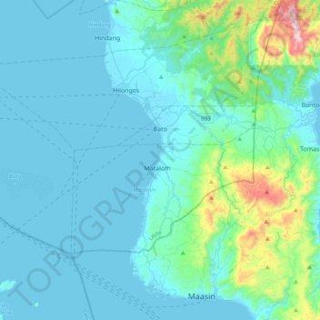
Naam: Topografische kaart Bato, hoogte, reliëf.
Gemiddelde hoogte: 111 m
Minimale hoogte: 0 m
Maximale hoogte: 931 m
Andere topografische kaarten
Klik op een kaart om zijn topografie, zijn hoogte en zijn reliëf te bekijken.
Pastrana
Pastrana, Leyte 2nd District, Leyte, Eastern Visayas, 6514, Philippines
Gemiddelde hoogte: 106 m
Lima
Philippines > Leyte > Pastrana > Lima
Lima, Pastrana, Leyte 2nd District, Leyte, Eastern Visayas, 6514, Philippines
Gemiddelde hoogte: 36 m
Dawahon
Philippines > Leyte > Dawahon
Dawahon, Bato, Leyte 5th District, Leyte, Eastern Visayas, 6525, Philippines
Gemiddelde hoogte: 0 m
Tacloban
Philippines > Leyte > Tacloban
Tacloban, Leyte, Eastern Visayas, 6500, Philippines
Gemiddelde hoogte: 29 m