
Topografische kaart Harpswell
Interactieve kaart
Klik op de kaart om de hoogte weer te geven.
Over deze kaart
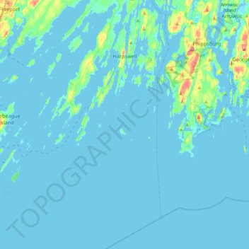
Naam: Topografische kaart Harpswell, hoogte, reliëf.
Locatie: Harpswell, Cumberland County, Maine, 04079, United States (43.60289 -70.07029 43.86625 -69.86999)
Gemiddelde hoogte: 5 m
Minimale hoogte: -2 m
Maximale hoogte: 78 m
Andere topografische kaarten
Klik op een kaart om zijn topografie, zijn hoogte en zijn reliëf te bekijken.
South Portland
United States > Maine > Cumberland County
South Portland, Cumberland County, Maine, 04106, United States
Gemiddelde hoogte: 9 m
Sebascodegan Island
United States > Maine > Cumberland County > Harpswell
Sebascodegan Island, Harpswell, Cumberland County, Maine, 04079, United States
Gemiddelde hoogte: 8 m
Little Sebago Lake
United States > Maine > Cumberland County > Gray
Little Sebago Lake, Gray, Cumberland County, Maine, 04039, United States
Gemiddelde hoogte: 108 m
Pownal
United States > Maine > Cumberland County
Pownal, Cumberland County, Maine, 04069, United States
Gemiddelde hoogte: 54 m
Cumberland
United States > Maine > Cumberland County
Cumberland, Cumberland County, Maine, United States
Gemiddelde hoogte: 51 m
Brunswick
United States > Maine > Cumberland County
Brunswick, Cumberland County, Maine, 04011, United States
Gemiddelde hoogte: 24 m
Crescent Beach
United States > Maine > Cumberland County > Cape Elizabeth
Crescent Beach, Cape Elizabeth, Cumberland County, Maine, 04107, United States
Gemiddelde hoogte: 6 m
Birch Island
United States > Maine > Cumberland County > Harpswell > Birch Island
Birch Island, Harpswell, Cumberland County, Maine, 04079, United States
Gemiddelde hoogte: 3 m
Falmouth
United States > Maine > Cumberland County
Falmouth, Cumberland County, Maine, 04105, United States
Gemiddelde hoogte: 29 m