
Topografische kaart Syracuse
Interactieve kaart
Klik op de kaart om de hoogte weer te geven.
Over deze kaart
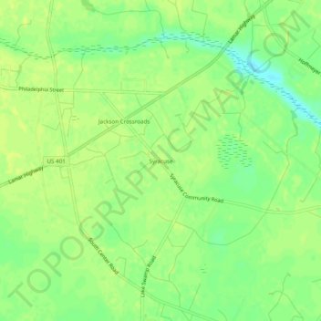
Naam: Topografische kaart Syracuse, hoogte, reliëf.
Locatie: Syracuse, Darlington County, South Carolina, United States (34.21126 -79.98729 34.25126 -79.94729)
Gemiddelde hoogte: 51 m
Minimale hoogte: 40 m
Maximale hoogte: 55 m
Andere topografische kaarten
Klik op een kaart om zijn topografie, zijn hoogte en zijn reliëf te bekijken.
Society Hill
United States > South Carolina > Darlington County
Society Hill, Darlington County, South Carolina, United States
Gemiddelde hoogte: 32 m
North Hartsville
United States > South Carolina > Darlington County
North Hartsville, Darlington County, South Carolina, United States
Gemiddelde hoogte: 68 m
Hartsville
United States > South Carolina > Darlington County > Hartsville
Hartsville, Darlington County, South Carolina, 29550, United States
Gemiddelde hoogte: 67 m
Spring Acres
United States > South Carolina > Darlington County > Spring Acres
Spring Acres, Darlington County, South Carolina, 29532, United States
Gemiddelde hoogte: 46 m
Darlington
United States > South Carolina > Darlington County > Darlington
Darlington, Darlington County, South Carolina, 29532, United States
Gemiddelde hoogte: 46 m
Hartsville
United States > South Carolina > Darlington County
Hartsville, Darlington County, South Carolina, 29550, United States
Gemiddelde hoogte: 65 m