
Topografische kaart Porcupine District
Interactieve kaart
Klik op de kaart om de hoogte weer te geven.
Over deze kaart
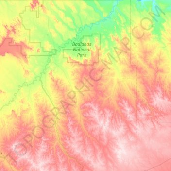
Naam: Topografische kaart Porcupine District, hoogte, reliëf.
Gemiddelde hoogte: 925 m
Minimale hoogte: 720 m
Maximale hoogte: 1.122 m
Andere topografische kaarten
Klik op een kaart om zijn topografie, zijn hoogte en zijn reliëf te bekijken.
Badlands National Park
United States > South Dakota > Oglala Lakota County
Badlands National Park, Oglala Lakota County, South Dakota, 57750, United States
Gemiddelde hoogte: 848 m
Red Shirt
United States > South Dakota > Oglala Lakota County
Red Shirt, White Clay District, Oglala Lakota County, South Dakota, United States
Gemiddelde hoogte: 845 m