
Topografische kaart Scofield Reservoir
Interactieve kaart
Klik op de kaart om de hoogte weer te geven.
Over deze kaart
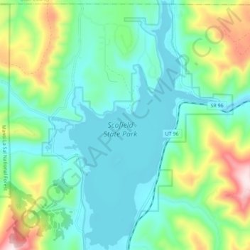
Naam: Topografische kaart Scofield Reservoir, hoogte, reliëf.
Locatie: Scofield Reservoir, Carbon County, Utah, United States (39.74814 -111.17269 39.81400 -111.11997)
Gemiddelde hoogte: 2.435 m
Minimale hoogte: 2.307 m
Maximale hoogte: 2.804 m
Scofield Reservoir is a 2,815-acre (11.39 km2) reservoir impounded by Scofield Dam, in Carbon County, Utah. Located on the Price River, a tributary of the Green River, Scofield Reservoir is adjacent to northernmost boundary of the Manti–La Sal National Forest. The reservoir sits at an elevation of 7,618 feet (2,322 m), on the northern edge of the Wasatch Plateau. Utah State Route 96 runs along the western shoreline.
Andere topografische kaarten
Klik op een kaart om zijn topografie, zijn hoogte en zijn reliëf te bekijken.
Carbonville
United States > Utah > Carbon County
Carbonville, Carbon County, Utah, 84591, United States
Gemiddelde hoogte: 1.741 m
Clear Creek
United States > Utah > Carbon County
Clear Creek, Carbon County, Utah, United States
Gemiddelde hoogte: 2.726 m
Helper
United States > Utah > Carbon County
Helper, Carbon County, Utah, United States
Gemiddelde hoogte: 1.912 m
Price
United States > Utah > Carbon County
Price, Carbon County, Utah, 84591, United States
Gemiddelde hoogte: 1.711 m
Price
United States > Utah > Carbon County > Price > Price
Price, Carbon County, Utah, 84501, United States
Gemiddelde hoogte: 1.728 m
Scofield
United States > Utah > Carbon County
Scofield, Carbon County, Utah, United States
Gemiddelde hoogte: 2.499 m