
Topografische kaart Village of Mamaroneck
Interactieve kaart
Klik op de kaart om de hoogte weer te geven.
Village of Mamaroneck
Other areas of the town include Heathcote Hill, overlooking the harbor, Harbor Heights (the heights) to the northeast, Old Rye Neck (settled in the 1880s), Rye Neck (settled in the 1920s and 1930s), Orienta, and Washingtonville, better known as "The Flats", due to the flat, low-lying topography of the area.
Over deze kaart
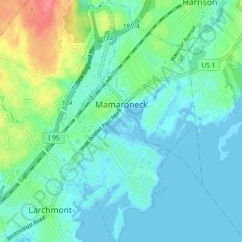
Naam: Topografische kaart Village of Mamaroneck, hoogte, reliëf.
Gemiddelde hoogte: 15 m
Minimale hoogte: -3 m
Maximale hoogte: 65 m
Andere topografische kaarten
Klik op een kaart om zijn topografie, zijn hoogte en zijn reliëf te bekijken.
Ward Pound Ridge Reservation
United States > New York > Westchester County > Town of Pound Ridge
Gemiddelde hoogte: 164 m
Riveredge Trailer Park
United States > New York > Westchester County > Town of Cortlandt > Verplanck
Gemiddelde hoogte: 14 m
Isle of San Souci
United States > New York > Westchester County > City of New Rochelle
Gemiddelde hoogte: 7 m
Wykagyl Park
United States > New York > Westchester County > City of New Rochelle
Gemiddelde hoogte: 41 m
Lake Waccabuc
United States > New York > Westchester County > Town of Lewisboro > Waccabuc
Gemiddelde hoogte: 173 m
Sherman Park
United States > New York > Westchester County > Town of Mount Pleasant > Thornwood
Gemiddelde hoogte: 133 m
Mariandale
United States > New York > Westchester County > Village of Ossining
Gemiddelde hoogte: 53 m
Pleasantside
United States > New York > Westchester County > Town of Cortlandt
Gemiddelde hoogte: 108 m
Salem Center
United States > New York > Westchester County > Town of North Salem
Gemiddelde hoogte: 147 m
Bonnie Crest
United States > New York > Westchester County > City of New Rochelle
Gemiddelde hoogte: 58 m
Vernon Park
United States > New York > Westchester County > City of Mount Vernon
Gemiddelde hoogte: 31 m
Lake Mohansic
United States > New York > Westchester County > Town of Yorktown
Gemiddelde hoogte: 159 m
West Harrison Village Green
United States > New York > Westchester County > Town/Village of Harrison > East White Plains
Gemiddelde hoogte: 79 m
Colonial Heights
United States > New York > Westchester County > City of Yonkers
Gemiddelde hoogte: 60 m
Sedge Island
United States > New York > Westchester County > City of New Rochelle
Gemiddelde hoogte: 47 m
Crestwood Gardens
United States > New York > Westchester County > City of Yonkers
Gemiddelde hoogte: 65 m
Jefferson Valley
United States > New York > Westchester County > Jefferson Valley-Yorktown
Gemiddelde hoogte: 178 m
Chauncey
United States > New York > Westchester County > Village of Dobbs Ferry
Gemiddelde hoogte: 76 m
Fenmore Park
United States > New York > Westchester County > Town/Village of Harrison
Gemiddelde hoogte: 38 m
Shore Acres
United States > New York > Westchester County > Village of Mamaroneck
Gemiddelde hoogte: 11 m
Bronxville Heights
United States > New York > Westchester County > City of Yonkers
Gemiddelde hoogte: 63 m
Mount Hope
United States > New York > Westchester County > Village of Hastings-on-Hudson
Gemiddelde hoogte: 60 m
New York, Westchester and Boston Railway
United States > New York > Westchester County > Village of Pelham > North Pelham
Gemiddelde hoogte: 28 m
Sleepy Hollow Manor
United States > New York > Westchester County > Village of Sleepy Hollow > Sleepy Hollow Manor
Gemiddelde hoogte: 41 m
Spring Valley
United States > New York > Westchester County > Town of Ossining > Ossining > Spring Valley
Gemiddelde hoogte: 115 m
Whitehall Corners
United States > New York > Westchester County > Town of Somers
Gemiddelde hoogte: 97 m
Sarles Corners
United States > New York > Westchester County > Town of Pound Ridge
Gemiddelde hoogte: 141 m
Secor Gardens
United States > New York > Westchester County > Village of Scarsdale
Gemiddelde hoogte: 70 m