
Topografische kaart Roslin
Interactieve kaart
Klik op de kaart om de hoogte weer te geven.
Over deze kaart
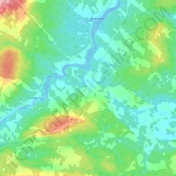
Naam: Topografische kaart Roslin, hoogte, reliëf.
Gemiddelde hoogte: 34 m
Minimale hoogte: -6 m
Maximale hoogte: 127 m
Andere topografische kaarten
Klik op een kaart om zijn topografie, zijn hoogte en zijn reliëf te bekijken.
Nappan
Canada > Nova Scotia > Municipality of the County of Cumberland
Nappan, Municipality of the County of Cumberland, Cumberland County, Nova Scotia, B0L 1C0, Canada
Gemiddelde hoogte: 25 m
Lorneville
Canada > Nova Scotia > Municipality of the County of Cumberland
Lorneville, Municipality of the County of Cumberland, Cumberland County, Nova Scotia, B4H 3X9, Canada
Gemiddelde hoogte: 20 m
Rockley
Canada > Nova Scotia > Municipality of the County of Cumberland
Rockley, Municipality of the County of Cumberland, Cumberland County, Nova Scotia, B0M 1V0, Canada
Gemiddelde hoogte: 24 m
Wentworth Provincial Park
Canada > Nova Scotia > Municipality of the County of Cumberland > Wentworth Station
Wentworth Provincial Park, Valley Road, Wentworth Station, Wentworth, Municipality of the County of Cumberland, Cumberland County, Nova Scotia, B0M 1Z0, Canada
Gemiddelde hoogte: 81 m
Isle Haute
Canada > Nova Scotia > Municipality of the County of Cumberland
Isle Haute, Municipality of the County of Cumberland, Cumberland County, Nova Scotia, Canada
Gemiddelde hoogte: 1 m
Fenwick
Canada > Nova Scotia > Municipality of the County of Cumberland
Fenwick, Municipality of the County of Cumberland, Cumberland County, Nova Scotia, B0L 1C0, Canada
Gemiddelde hoogte: 79 m