
Topografische kaart Mitikas
Interactieve kaart
Klik op de kaart om de hoogte weer te geven.
Over deze kaart
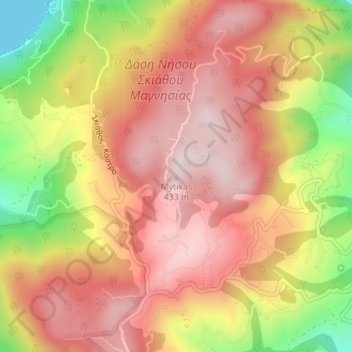
Naam: Topografische kaart Mitikas, hoogte, reliëf.
Gemiddelde hoogte: 261 m
Minimale hoogte: 0 m
Maximale hoogte: 423 m
Andere topografische kaarten
Klik op een kaart om zijn topografie, zijn hoogte en zijn reliëf te bekijken.
Skiathos
Greece > Thessaly and Central Greece > Sporades Regional Unit > Σκιάθος
Skiathos, Σκιάθος, Skiathos Municipality, Sporades Regional Unit, Thessaly, Thessaly and Central Greece, 370 02, Greece
Gemiddelde hoogte: 44 m