
Topografische kaart Khatanga
Interactieve kaart
Klik op de kaart om de hoogte weer te geven.
Over deze kaart
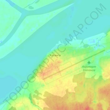
Naam: Topografische kaart Khatanga, hoogte, reliëf.
Gemiddelde hoogte: 11 m
Minimale hoogte: -4 m
Maximale hoogte: 38 m
Khatanga (Russian: Ха́танга) is a rural locality (a selo) in Taymyrsky Dolgano-Nenetsky District of Krasnoyarsk Krai, Russia, located on the Khatanga River on the Taymyr Peninsula. It is one of the northernmost inhabited localities in Russia. Its elevation is 30 metres (98 ft) above sea level. As of the 2002 Census, its population was 3,450.