
Topografische kaart Square Butte
Interactieve kaart
Klik op de kaart om de hoogte weer te geven.
Over deze kaart
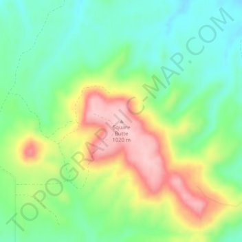
Naam: Topografische kaart Square Butte, hoogte, reliëf.
Gemiddelde hoogte: 884 m
Minimale hoogte: 805 m
Maximale hoogte: 1.009 m
Andere topografische kaarten
Klik op een kaart om zijn topografie, zijn hoogte en zijn reliëf te bekijken.
Forman
United States of America > North Dakota > Forman
Forman, Sargent County, North Dakota, 58032, United States of America
Gemiddelde hoogte: 383 m
Tongue River
United States of America > North Dakota
Tongue River, Pembina County, North Dakota, United States of America
Gemiddelde hoogte: 245 m
Parshall
United States of America > North Dakota > Parshall
Parshall, Mountrail County, North Dakota, United States of America
Gemiddelde hoogte: 598 m
Pillsbury
United States of America > North Dakota > Pillsbury > Pillsbury
Pillsbury, Barnes County, North Dakota, United States of America
Gemiddelde hoogte: 388 m