
Topografische kaart Sereď
Interactieve kaart
Klik op de kaart om de hoogte weer te geven.
Over deze kaart
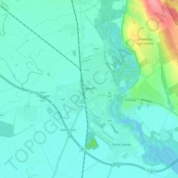
Naam: Topografische kaart Sereď, hoogte, reliëf.
Gemiddelde hoogte: 132 m
Minimale hoogte: 117 m
Maximale hoogte: 204 m
Sereď lies at an altitude of 129 metres (423 ft) above sea level and covers an area of 30.454 square kilometres (11.8 sq mi). It is located in the Danubian Lowland on the Váh river, around 20 kilometres (12 mi) south-east of Trnava, 33 kilometres (21 mi) west of Nitra and around 55 kilometres (34 mi) east from Bratislava. The closest mountain ranges are the Little Carpathians to the west and Považský Inovec to the north.
Andere topografische kaarten
Klik op een kaart om zijn topografie, zijn hoogte en zijn reliëf te bekijken.
Sládkovičovo
Slovakia > Region of Trnava > District of Galanta
Sládkovičovo, District of Galanta, Region of Trnava, Western Slovakia, 925 21, Slovakia
Gemiddelde hoogte: 120 m
Šintava
Slovakia > Region of Trnava > District of Galanta
Šintava, District of Galanta, Region of Trnava, Western Slovakia, 925 51, Slovakia
Gemiddelde hoogte: 138 m