
Doe een donatie
Rust jezelf uit voor je volgende avontuur:
Als Amazon-partner verdient deze site een commissie op in aanmerking komende aankopen, zonder extra kosten voor jou.
Topografische kaart Harrison Mills
Klik op de kaart om de hoogte weer te geven.
Doe een donatie
Rust jezelf uit voor je volgende avontuur:
Als Amazon-partner verdient deze site een commissie op in aanmerking komende aankopen, zonder extra kosten voor jou.
Over deze kaart
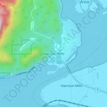
Naam: Topografische kaart Harrison Mills, hoogte, reliëf.
Gemiddelde hoogte: 95 m
Minimale hoogte: -1 m
Maximale hoogte: 902 m
Doe een donatie
Rust jezelf uit voor je volgende avontuur:
Als Amazon-partner verdient deze site een commissie op in aanmerking komende aankopen, zonder extra kosten voor jou.
Andere topografische kaarten
Klik op een kaart om zijn topografie, zijn hoogte en zijn reliëf te bekijken.
Harrison Lake
Canada > British Columbia > Fraser Valley Regional District > Area C (Sasquatch Country)
Gemiddelde hoogte: 815 m
Chehalis Lake
Canada > British Columbia > Fraser Valley Regional District > Area C (Sasquatch Country)
Gemiddelde hoogte: 735 m
Glacier Lake
Canada > British Columbia > Fraser Valley Regional District > Area C (Sasquatch Country)
Gemiddelde hoogte: 614 m
Sloquet Creek
Canada > British Columbia > Fraser Valley Regional District > Area C (Sasquatch Country)
Gemiddelde hoogte: 255 m
Doe een donatie
Rust jezelf uit voor je volgende avontuur:
Als Amazon-partner verdient deze site een commissie op in aanmerking komende aankopen, zonder extra kosten voor jou.
Chehalis River
Canada > British Columbia > Fraser Valley Regional District > Area C (Sasquatch Country)
Gemiddelde hoogte: 424 m
Harrison-Chehalis Wildlife Management Area
Canada > British Columbia > Fraser Valley Regional District > Area C (Sasquatch Country) > Harrison Mills
Gemiddelde hoogte: 187 m
Turner Glacier
Canada > British Columbia > Fraser Valley Regional District > Area C (Sasquatch Country)
Gemiddelde hoogte: 2.183 m