
Topografische kaart Grass Valley
Interactieve kaart
Klik op de kaart om de hoogte weer te geven.
Over deze kaart
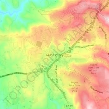
Naam: Topografische kaart Grass Valley, hoogte, reliëf.
Locatie: Grass Valley, Nevada County, California, United States (39.19381 -121.08282 39.24440 -121.00559)
Gemiddelde hoogte: 775 m
Minimale hoogte: 618 m
Maximale hoogte: 921 m
Grass Valley is a city in Nevada County, California, United States. Situated at roughly 2,500 feet (760 m) elevation in the western foothills of the Sierra Nevada mountain range, this historic northern Gold Country city is 57 miles (92 km) by car from the state capitol in Sacramento, 64 miles (103 km) from Sacramento International Airport, 88 miles (142 km) west of Reno, and 143 miles (230 km) northeast of San Francisco. As of the 2010 United States Census, its population was 12,860.
Andere topografische kaarten
Klik op een kaart om zijn topografie, zijn hoogte en zijn reliëf te bekijken.
Cypress Hill
United States > California > Nevada County > Grass Valley
Cypress Hill, Grass Valley, Nevada County, California, 95945, United States
Gemiddelde hoogte: 786 m
Hills Flat
United States > California > Nevada County > Grass Valley
Hills Flat, Grass Valley, Nevada County, California, 95945, United States
Gemiddelde hoogte: 802 m
Spring Hill
United States > California > Nevada County > Grass Valley > Spring Hill
Spring Hill, Grass Valley, Nevada County, California, 95954, United States
Gemiddelde hoogte: 807 m
Boston Ravine
United States > California > Nevada County > Grass Valley
Boston Ravine, Grass Valley, Nevada County, California, 95945, United States
Gemiddelde hoogte: 755 m