
Topografische kaart Williamson County
Interactieve kaart
Klik op de kaart om de hoogte weer te geven.
Over deze kaart
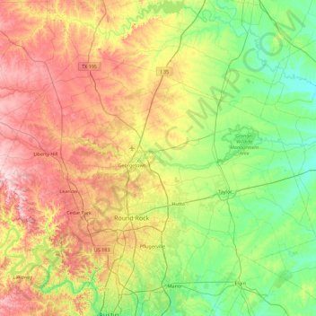
Naam: Topografische kaart Williamson County, hoogte, reliëf.
Locatie: Williamson County, Texas, United States (30.40281 -98.05005 30.90559 -97.15520)
Gemiddelde hoogte: 222 m
Minimale hoogte: 110 m
Maximale hoogte: 417 m
The area is divided into two regions by the Balcones Escarpment, which runs through the center from north to south along a line from Jarrell to Georgetown to Round Rock. The county's western half is an extension of the Western Plains and considered to be within the eastern fringes of Texas Hill Country; it has an average elevation of 850 ft (260 m). It features undulating, hilly brushland with an abundance of Texas live oak, prickly pear cactus, and karst. The county's eastern half is part of the Coastal Plains and is flat to gently rolling with an average elevation of 600 ft (180 m). It has dark clay and rich, fertile soils for agriculture, but is quickly being developed as the county's population continues to increase and expand out. Williamson County is drained in the center and south by the San Gabriel River, the county's only river, and in the north by creeks that run into the Lampasas and Little Rivers north of the county line.
Andere topografische kaarten
Klik op een kaart om zijn topografie, zijn hoogte en zijn reliëf te bekijken.
Kingwood
United States > Texas > Harris County > Houston
Kingwood, Houston, Harris County, Texas, 77345, United States
Gemiddelde hoogte: 22 m
Houston
United States > Texas > Harris County
Houston, Harris County, Texas, United States
Gemiddelde hoogte: 25 m
Dallas
United States > Texas > Dallas County
Dallas, Dallas County, Texas, United States
Gemiddelde hoogte: 160 m
San Antonio
United States > Texas > Bexar County
San Antonio, Bexar County, Texas, United States
Gemiddelde hoogte: 247 m
Conroe
United States > Texas > Montgomery County
Conroe, Montgomery County, Texas, United States
Gemiddelde hoogte: 62 m
Austin
United States > Texas > Travis County
Austin, Travis County, Texas, United States
Gemiddelde hoogte: 216 m
Cypress
United States > Texas > Harris County
Cypress, Harris County, Texas, 77433, United States
Gemiddelde hoogte: 46 m
Frisco
United States > Texas > Collin County
Frisco, Collin County, Texas, United States
Gemiddelde hoogte: 201 m
Katy
United States > Texas > Fort Bend County
Katy, Fort Bend County, Texas, United States
Gemiddelde hoogte: 44 m
McKinney
United States > Texas > Collin County
McKinney, Collin County, Texas, United States
Gemiddelde hoogte: 193 m
El Paso
United States > Texas > El Paso County
El Paso, El Paso County, Texas, United States
Gemiddelde hoogte: 1.237 m
Willis
United States > Texas > Montgomery County
Willis, Montgomery County, Texas, 77305, United States
Gemiddelde hoogte: 99 m
Amarillo
United States > Texas > Potter County
Amarillo, Potter County, Texas, United States
Gemiddelde hoogte: 1.097 m
Granbury
United States > Texas > Hood County
Granbury, Hood County, Texas, 76048, United States
Gemiddelde hoogte: 242 m
San Angelo
United States > Texas > Tom Green County
San Angelo, Tom Green County, Texas, United States
Gemiddelde hoogte: 576 m
Montgomery County
Montgomery County, Texas, United States
Gemiddelde hoogte: 69 m
Arlington
United States > Texas > Tarrant County
Arlington, Tarrant County, Texas, United States
Gemiddelde hoogte: 174 m
Livingston
United States > Texas > Polk County
Livingston, Polk County, Texas, United States
Gemiddelde hoogte: 63 m
San Marcos
United States > Texas > Hays County
San Marcos, Hays County, Texas, 78666, United States
Gemiddelde hoogte: 208 m
Plano
United States > Texas > Collin County
Plano, Collin County, Texas, United States
Gemiddelde hoogte: 196 m
Georgetown
United States > Texas > Williamson County
Georgetown, Williamson County, Texas, United States
Gemiddelde hoogte: 247 m
Canyon Lake
United States > Texas > Comal County
Canyon Lake, Comal County, Texas, 78133, United States
Gemiddelde hoogte: 296 m
Magnolia
United States > Texas > Montgomery County
Magnolia, Montgomery County, Texas, United States
Gemiddelde hoogte: 77 m
Sugar Land
United States > Texas > Fort Bend County
Sugar Land, Fort Bend County, Texas, United States
Gemiddelde hoogte: 24 m
Baytown
United States > Texas > Harris County
Baytown, Harris County, Texas, United States
Gemiddelde hoogte: 7 m
Abilene
United States > Texas > Taylor County
Abilene, Taylor County, Texas, United States
Gemiddelde hoogte: 533 m
Spring
United States > Texas > Harris County
Spring, Harris County, Texas, 77373, United States
Gemiddelde hoogte: 35 m
Cedar Park
United States > Texas > Williamson County
Cedar Park, Williamson County, Texas, United States
Gemiddelde hoogte: 288 m
Waco
United States > Texas > McLennan County
Waco, McLennan County, Texas, United States
Gemiddelde hoogte: 147 m
Rockport
United States > Texas > Aransas County
Rockport, Aransas County, Texas, 78382, United States
Gemiddelde hoogte: 3 m
Fort Worth
United States > Texas > Tarrant County
Fort Worth, Tarrant County, Texas, United States
Gemiddelde hoogte: 212 m
Boerne
United States > Texas > Kendall County
Boerne, Kendall County, Texas, United States
Gemiddelde hoogte: 465 m
Laredo
United States > Texas > Webb County
Laredo, Webb County, Texas, United States
Gemiddelde hoogte: 160 m
Kerrville
United States > Texas > Kerr County
Kerrville, Kerr County, Texas, United States
Gemiddelde hoogte: 545 m
Weatherford
United States > Texas > Parker County
Weatherford, Parker County, Texas, 76086, United States
Gemiddelde hoogte: 326 m
Galveston
United States > Texas > Galveston County
Galveston, Galveston County, Texas, United States
Gemiddelde hoogte: 1 m
Wichita Falls
United States > Texas > Wichita County
Wichita Falls, Wichita County, Texas, United States
Gemiddelde hoogte: 300 m
Fredericksburg
United States > Texas > Gillespie County
Fredericksburg, Gillespie County, Texas, United States
Gemiddelde hoogte: 526 m
Alpine
United States > Texas > Brewster County
Alpine, Brewster County, Texas, United States
Gemiddelde hoogte: 1.373 m