
Topografische kaart Lewisville
Interactieve kaart
Klik op de kaart om de hoogte weer te geven.
Over deze kaart
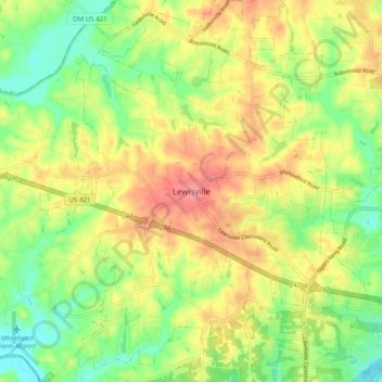
Naam: Topografische kaart Lewisville, hoogte, reliëf.
Gemiddelde hoogte: 251 m
Minimale hoogte: 208 m
Maximale hoogte: 300 m
Andere topografische kaarten
Klik op een kaart om zijn topografie, zijn hoogte en zijn reliëf te bekijken.
Vienna
United States > North Carolina > Forsyth County > Lewisville
Vienna, Lewisville, Forsyth County, North Carolina, 27040, United States
Gemiddelde hoogte: 261 m
Sherwood Forest
United States > North Carolina > Forsyth County > Lewisville
Sherwood Forest, Lewisville, Forsyth County, North Carolina, 27040, United States
Gemiddelde hoogte: 257 m
Eaglewood
United States > North Carolina > Forsyth County > Lewisville
Eaglewood, Lewisville, Forsyth County, North Carolina, 27023, United States
Gemiddelde hoogte: 261 m