
Topografische kaart Alston
Interactieve kaart
Klik op de kaart om de hoogte weer te geven.
Alston
Alston is a town in Cumbria, England, within the civil parish of Alston Moor on the River South Tyne. It shares the title of the 'highest market town in England', at about 1,000 feet (300 m) above sea level, with Buxton, Derbyshire. Despite its altitude, the town is easily accessible via the many roads which link the town to Weardale, Teesdale, and towns in Cumbria such as Penrith via Hartside Pass, as well as Tynedale. Historically part of Cumberland, Alston lies within the North Pennines, a designated Area of Outstanding Natural Beauty. Much of the town centre is a designated Conservation Area which includes several listed buildings.
Over deze kaart
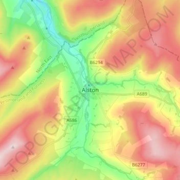
Naam: Topografische kaart Alston, hoogte, reliëf.
Gemiddelde hoogte: 404 m
Minimale hoogte: 221 m
Maximale hoogte: 598 m
Andere topografische kaarten
Klik op een kaart om zijn topografie, zijn hoogte en zijn reliëf te bekijken.