
Topografische kaart Saint Helena Island
Interactieve kaart
Klik op de kaart om de hoogte weer te geven.
Over deze kaart
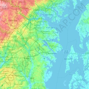
Naam: Topografische kaart Saint Helena Island, hoogte, reliëf.
Gemiddelde hoogte: 33 m
Minimale hoogte: -4 m
Maximale hoogte: 204 m
Andere topografische kaarten
Klik op een kaart om zijn topografie, zijn hoogte en zijn reliëf te bekijken.
Severn River
USA > Maryland > Winchester-on-the-Severn
Severn River, Beach Drive, Winchester-on-the-Severn, Parole, Winchester-on-the-Severn, Anne Arundel County, Maryland, 21401, USA
Gemiddelde hoogte: 13 m
Sugarloaf Mountain
Sugarloaf Mountain, Frederick County, Maryland, 20842, USA
Gemiddelde hoogte: 200 m
Mount Rainier
USA > Maryland > Mount Rainier
Mount Rainier, Prince George's County, Maryland, 20712, USA
Gemiddelde hoogte: 22 m
Tiber River Park
USA > Maryland > Ellicott City
Tiber River Park, Hilltop, Dorsey's Search, Ellicott City, Howard County, Maryland, USA
Gemiddelde hoogte: 96 m
Chrome Hill
USA > Maryland > Chrome Hill
Chrome Hill, Harford County, Maryland, USA
Gemiddelde hoogte: 134 m
Long Meadow
USA > Maryland > Long Meadow
Long Meadow, Washington County, Maryland, 21767, USA
Gemiddelde hoogte: 192 m
Maryland Park
USA > Maryland > Maryland Park
Maryland Park, Prince George's County, Maryland, 20743, USA
Gemiddelde hoogte: 48 m
Savage River
Savage River, Garrett County, Maryland, 21523, USA
Gemiddelde hoogte: 687 m
Victoria Station
USA > Maryland > Victoria Station
Victoria Station, Calvert County, Maryland, 20736, USA
Gemiddelde hoogte: 38 m
Grahams Green Acres
USA > Maryland > Grahams Green Acres
Grahams Green Acres, Carroll County, Maryland, 21776, USA
Gemiddelde hoogte: 223 m
Loch Leven
USA > Maryland > Loch Leven
Loch Leven, Harford County, Maryland, USA
Gemiddelde hoogte: 107 m
South River
USA > Maryland > Withernsea
South River, Rolling Road, Annapolis Landing, Withernsea, Anne Arundel County, Maryland, 21037, USA
Gemiddelde hoogte: 10 m
White Marsh
USA > Maryland > White Marsh
White Marsh, Baltimore County, Maryland, 21128, USA
Gemiddelde hoogte: 36 m