
Topografische kaart Barnstable County
Interactieve kaart
Klik op de kaart om de hoogte weer te geven.
Over deze kaart
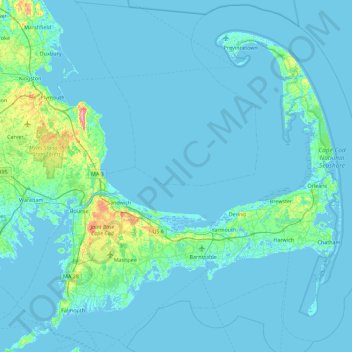
Naam: Topografische kaart Barnstable County, hoogte, reliëf.
Locatie: Barnstable County, Massachusetts, United States of America (41.48044 -70.76063 42.13365 -69.86010)
Gemiddelde hoogte: 7 m
Minimale hoogte: -8 m
Maximale hoogte: 113 m
The highest elevation in the county is 306 feet (93 m) on the summit of Pine Hill, located on Joint Base Cape Cod in Bourne. The lowest point is sea level.
Andere topografische kaarten
Klik op een kaart om zijn topografie, zijn hoogte en zijn reliëf te bekijken.
North Attleborough
United States of America > Massachusetts > North Attleborough > North Attleborough
North Attleborough, Bristol County, Massachusetts, 02760, United States of America
Gemiddelde hoogte: 54 m
Hampshire County
United States of America > Massachusetts
Hampshire County, Massachusetts, United States of America
Gemiddelde hoogte: 243 m
Hampden County
United States of America > Massachusetts
Hampden County, Massachusetts, United States of America
Gemiddelde hoogte: 209 m
Berkshire County
United States of America > Massachusetts
Berkshire County, Massachusetts, United States of America
Gemiddelde hoogte: 359 m
Bristol County
United States of America > Massachusetts
Bristol County, Massachusetts, United States of America
Gemiddelde hoogte: 26 m