
Topografische kaart Sayre
Interactieve kaart
Klik op de kaart om de hoogte weer te geven.
Sayre
Sayre is located at 35°17′56″N 99°38′12″W / 35.29889°N 99.63667°W / 35.29889; -99.63667 (35.298940, -99.636556). It is located on the North Fork of the Red River, at an elevation of 1,800 feet (550 m) and 128 miles (206 km) west of Oklahoma City. The area is dominated by low rolling red clay hills.
Over deze kaart
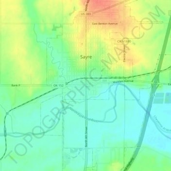
Naam: Topografische kaart Sayre, hoogte, reliëf.
Locatie: Sayre, Beckham County, Oklahoma, 73662, United States (35.27116 -99.66010 35.31116 -99.62010)
Gemiddelde hoogte: 560 m
Minimale hoogte: 541 m
Maximale hoogte: 588 m