
Topografische kaart Largo
Interactieve kaart
Klik op de kaart om de hoogte weer te geven.
Over deze kaart
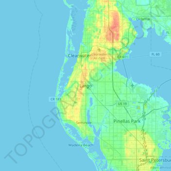
Naam: Topografische kaart Largo, hoogte, reliëf.
Locatie: Largo, Pinellas County, Florida, 33770-1815, United States (27.74947 -82.94732 28.06947 -82.62732)
Gemiddelde hoogte: 5 m
Minimale hoogte: -2 m
Maximale hoogte: 35 m
In 2010, Largo's total area was 18.6 square miles (48.1 km2), of which 17.6 square miles (45.6 km2) was land and 0.97 square miles (2.5 km2), or 5.22%, was water. As of 2004, there were 651 acres (2.6 km2) of park lands. The city's lowest elevation is sea level. At its highest, the city's elevation is about 69 feet (21 m). Largo is dotted with a number of lakes, the largest of which is Taylor Lake at 53 acres (210,000 m2). Allen's Creek drains northeast Largo, flowing into Tampa Bay. McKay Creek flows through southwest Largo into the Intracoastal Waterway. The McKay Creek basin is prone to flooding.
Andere topografische kaarten
Klik op een kaart om zijn topografie, zijn hoogte en zijn reliëf te bekijken.
Ridgecrest
United States > Florida > Pinellas County > Largo > Baskin
Ridgecrest, Baskin, Largo, Pinellas County, Florida, United States
Gemiddelde hoogte: 18 m
Taylor Park
United States > Florida > Pinellas County > Largo > Ridgecrest
Taylor Park, Ridgecrest, Largo, Pinellas County, Florida, 33770, United States
Gemiddelde hoogte: 18 m
Anona
United States > Florida > Pinellas County > Largo > Anona
Anona, Largo, Pinellas County, Florida, 33774, United States
Gemiddelde hoogte: 9 m
Baskin
United States > Florida > Pinellas County > Largo > Baskin
Baskin, Largo, Pinellas County, Florida, 33778, United States
Gemiddelde hoogte: 14 m