
Doe een donatie
Rust jezelf uit voor je volgende avontuur:
Als Amazon-partner verdient deze site een commissie op in aanmerking komende aankopen, zonder extra kosten voor jou.
Topografische kaart McCall
Klik op de kaart om de hoogte weer te geven.
Doe een donatie
Rust jezelf uit voor je volgende avontuur:
Als Amazon-partner verdient deze site een commissie op in aanmerking komende aankopen, zonder extra kosten voor jou.
McCall
Brundage Mountain, northwest of McCall, opened in November 1961. Brundage has a summit elevation of 7,803 feet (2,380 m) above sea level, and a vertical drop of 1,921 feet (590 m). The slopes on Brundage Mountain are primarily west-facing and the mountain's average snowfall exceeds 320 inches (810 cm). It currently has five chairlifts and one Magic Carpet (two high-speed quad chairs, three triple chairs, and one magic carpet) with a capacity of 9,000 people per hour. The lifts afford access to 1920 acres of terrain, including 420 acres of lift-accessed, un-patrolled, without avalanche mitigation, backcountry terrain. The resort also operates a backcountry snowcat skiing operation which provides guided access to 18,000 acres (73 km2) of untracked powder in the Payette National Forest north of the ski area. There are also three terrain parks of varying difficulty. Summer activities include lift-served mountain biking trails, scenic chairlift rides, summer concerts, yoga and other calendared events. Brundage was owned by the DeBoer family, descendants of early McCall pioneers, with J. R. Simplot. In April 2016, the DeBoers took full control of the property, purchasing the 50% interest of the his family. In 2020, ownership was transferred to Brundage Mountain Holdings with the DeBoer family maintaining an ownership stake.
Doe een donatie
Rust jezelf uit voor je volgende avontuur:
Als Amazon-partner verdient deze site een commissie op in aanmerking komende aankopen, zonder extra kosten voor jou.
Over deze kaart
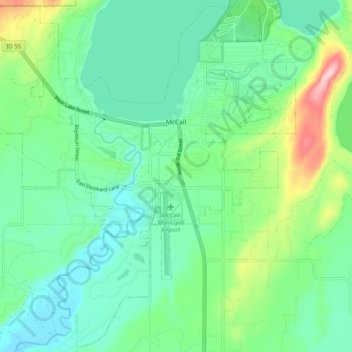
Naam: Topografische kaart McCall, hoogte, reliëf.
Locatie: McCall, Valley County, Idaho, 83638, United States (44.86605 -116.16411 44.93408 -116.06501)
Gemiddelde hoogte: 1.546 m
Minimale hoogte: 1.491 m
Maximale hoogte: 1.703 m
Doe een donatie
Rust jezelf uit voor je volgende avontuur:
Als Amazon-partner verdient deze site een commissie op in aanmerking komende aankopen, zonder extra kosten voor jou.
Andere topografische kaarten
Klik op een kaart om zijn topografie, zijn hoogte en zijn reliëf te bekijken.
Doe een donatie
Rust jezelf uit voor je volgende avontuur:
Als Amazon-partner verdient deze site een commissie op in aanmerking komende aankopen, zonder extra kosten voor jou.
Doe een donatie
Rust jezelf uit voor je volgende avontuur:
Als Amazon-partner verdient deze site een commissie op in aanmerking komende aankopen, zonder extra kosten voor jou.