
Topografische kaart Kodaikanal
Interactieve kaart
Klik op de kaart om de hoogte weer te geven.
Kodaikanal
Kodaikanal has a monsoon-influenced subtropical highland climate (Cfb, according to the Köppen climate classification, with a Cwb tendency). The temperatures are cool throughout the year due to the high elevation of the city.
Over deze kaart
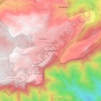
Naam: Topografische kaart Kodaikanal, hoogte, reliëf.
Locatie: Kodaikanal, Dindigul District, Tamil Nadu, 624100, India (10.19512 77.45383 10.27512 77.53383)
Gemiddelde hoogte: 1.763 m
Minimale hoogte: 506 m
Maximale hoogte: 2.337 m
Andere topografische kaarten
Klik op een kaart om zijn topografie, zijn hoogte en zijn reliëf te bekijken.