
Topografische kaart Doylestown
Interactieve kaart
Klik op de kaart om de hoogte weer te geven.
Over deze kaart
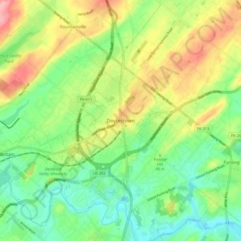
Naam: Topografische kaart Doylestown, hoogte, reliëf.
Locatie: Doylestown, Bucks County, Pennsylvania, 18901, United States (40.27004 -75.17046 40.35004 -75.09046)
Gemiddelde hoogte: 100 m
Minimale hoogte: 51 m
Maximale hoogte: 175 m
An electric telegraph station was built in 1846, and the North Pennsylvania Railroad completed a branch to Doylestown in 1856. The first gas lights were introduced in 1854. Because of the town's relatively high elevation and a lack of strong water power, substantial industrial development never occurred and Doylestown evolved to have a professional and residential character.