
Doe een donatie
Rust jezelf uit voor je volgende avontuur:
Als Amazon-partner verdient deze site een commissie op in aanmerking komende aankopen, zonder extra kosten voor jou.
Topografische kaart Acerno
Klik op de kaart om de hoogte weer te geven.
Doe een donatie
Rust jezelf uit voor je volgende avontuur:
Als Amazon-partner verdient deze site een commissie op in aanmerking komende aankopen, zonder extra kosten voor jou.
Acerno
The communal territory has an elevation varying between 400 and 1790 metres above sea level. Outside of the town itself it is entirely uninhabited by humans: there are no satellite hamlets or even scattered dwellings under permanent habitation. It is rich in flora, however, with forests of maple, oak, chestnut, hazel, beech and alder, while the fauna includes golden eagles, dormice, wild cats, otters and wolves.
Doe een donatie
Rust jezelf uit voor je volgende avontuur:
Als Amazon-partner verdient deze site een commissie op in aanmerking komende aankopen, zonder extra kosten voor jou.
Over deze kaart
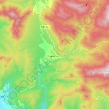
Naam: Topografische kaart Acerno, hoogte, reliëf.
Locatie: Acerno, Salerno, Campania, 84042, Italy (40.69710 15.00360 40.78177 15.14572)
Gemiddelde hoogte: 954 m
Minimale hoogte: 241 m
Maximale hoogte: 1.778 m
Doe een donatie
Rust jezelf uit voor je volgende avontuur:
Als Amazon-partner verdient deze site een commissie op in aanmerking komende aankopen, zonder extra kosten voor jou.
Andere topografische kaarten
Klik op een kaart om zijn topografie, zijn hoogte en zijn reliëf te bekijken.
Doe een donatie
Rust jezelf uit voor je volgende avontuur:
Als Amazon-partner verdient deze site een commissie op in aanmerking komende aankopen, zonder extra kosten voor jou.