
Topografische kaart Charles River
Interactieve kaart
Klik op de kaart om de hoogte weer te geven.
Over deze kaart
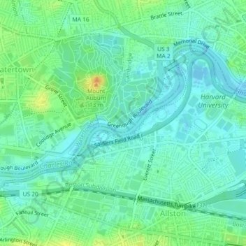
Naam: Topografische kaart Charles River, hoogte, reliëf.
Gemiddelde hoogte: 10 m
Minimale hoogte: -2 m
Maximale hoogte: 31 m
As native populations were driven out by European settlers, the Charles River became an early center for hydropower and manufacturing in North America. Although in portions of its length, the Charles drops slowly in elevation and has relatively little current, early settlers in Dedham, Massachusetts, found a way to use the Charles to power mills. In 1639, the town dug a canal from the Charles to a nearby brook that drained to the Neponset River. By this action, a portion of the Charles's flow was diverted, providing enough current for several mills. The new canal and the brook together are now called Mother Brook. The canal is regarded as the first industrial canal in North America. It remains in use for flood control.
Andere topografische kaarten
Klik op een kaart om zijn topografie, zijn hoogte en zijn reliëf te bekijken.
Brighton
United States > Massachusetts > Suffolk County > Boston
Brighton, Boston, Suffolk County, Massachusetts, 02135, United States
Gemiddelde hoogte: 31 m
Bunker Hill Monument
United States > Massachusetts > Suffolk County > Boston
Bunker Hill Monument, Monument Square, Charlestown, Boston, Suffolk County, Massachusetts, 02129, United States
Gemiddelde hoogte: 6 m
Boston Harbor
United States > Massachusetts > Suffolk County > Boston
Boston Harbor, Boston, Suffolk County, Massachusetts, 02152, United States
Gemiddelde hoogte: 1 m
Prescott Square
United States > Massachusetts > Suffolk County > Boston
Prescott Square, Eagle Hill, East Boston, Boston, Suffolk County, Massachusetts, United States
Gemiddelde hoogte: 7 m
Savin Hill Park
United States > Massachusetts > Suffolk County > Boston
Savin Hill Park, Savin Hill, Dorchester, Boston, Suffolk County, Massachusetts, United States
Gemiddelde hoogte: 7 m
Jamaica Pond
United States > Massachusetts > Suffolk County > Boston
Jamaica Pond, Jamaica Plain, Boston, Suffolk County, Massachusetts, United States
Gemiddelde hoogte: 34 m
Bellevue Hill
United States > Massachusetts > Suffolk County > Boston
Bellevue Hill, Boston, Suffolk County, Massachusetts, 02132, United States
Gemiddelde hoogte: 51 m
Bunker Hill
United States > Massachusetts > Suffolk County > Boston
Bunker Hill, Boston, Suffolk County, Massachusetts, 02129, United States
Gemiddelde hoogte: 6 m
Franklin Park
United States > Massachusetts > Suffolk County > Boston
Franklin Park, Roxbury, Boston, Suffolk County, Massachusetts, United States
Gemiddelde hoogte: 30 m
Breeds Hill
United States > Massachusetts > Suffolk County > Boston
Breeds Hill, Boston, Suffolk County, Massachusetts, 02129, United States
Gemiddelde hoogte: 6 m
Little Brewster Island
United States > Massachusetts > Suffolk County > Boston
Little Brewster Island, Boston, Suffolk County, Massachusetts, United States
Gemiddelde hoogte: 0 m
Spectacle Island
United States > Massachusetts > Suffolk County > Boston
Spectacle Island, Boston, Suffolk County, Massachusetts, United States
Gemiddelde hoogte: 1 m
Georges Island
United States > Massachusetts > Suffolk County > Boston
Georges Island, Boston, Suffolk County, Massachusetts, 02045, United States
Gemiddelde hoogte: 25 m
Pleasure Bay
United States > Massachusetts > Suffolk County > Boston
Pleasure Bay, Boston, Suffolk County, Massachusetts, 02127, United States
Gemiddelde hoogte: 2 m