
Topografische kaart Decatur City
Interactieve kaart
Klik op de kaart om de hoogte weer te geven.
Over deze kaart
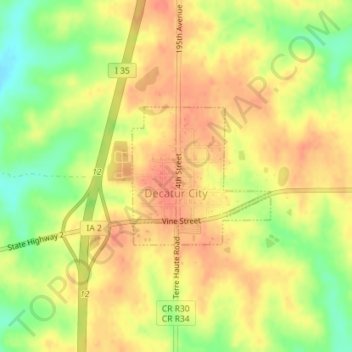
Naam: Topografische kaart Decatur City, hoogte, reliëf.
Locatie: Decatur City, Decatur County, Iowa, 50067, United States (40.73763 -93.83820 40.74823 -93.82418)
Gemiddelde hoogte: 334 m
Minimale hoogte: 305 m
Maximale hoogte: 350 m
Andere topografische kaarten
Klik op een kaart om zijn topografie, zijn hoogte en zijn reliëf te bekijken.
Van Wert
United States > Iowa > Decatur County
Van Wert, Decatur County, Iowa, United States
Gemiddelde hoogte: 346 m
Pleasanton
United States > Iowa > Decatur County
Pleasanton, Decatur County, Iowa, United States
Gemiddelde hoogte: 320 m
Davis City
United States > Iowa > Decatur County
Davis City, Decatur County, Iowa, 50065, United States
Gemiddelde hoogte: 281 m
Leon
United States > Iowa > Decatur County
Leon, Decatur County, Iowa, 50144, United States
Gemiddelde hoogte: 331 m
Garden Grove
United States > Iowa > Decatur County
Garden Grove, Decatur County, Iowa, United States
Gemiddelde hoogte: 329 m
Weldon
United States > Iowa > Decatur County
Weldon, Decatur County, Iowa, United States
Gemiddelde hoogte: 346 m
Lamoni
United States > Iowa > Decatur County
Lamoni, Decatur County, Iowa, 50140, United States
Gemiddelde hoogte: 341 m
Grand River
United States > Iowa > Decatur County
Grand River, Decatur County, Iowa, United States
Gemiddelde hoogte: 313 m
Le Roy
United States > Iowa > Decatur County
Le Roy, Decatur County, Iowa, United States
Gemiddelde hoogte: 337 m