
Topografische kaart Samarina
Interactieve kaart
Klik op de kaart om de hoogte weer te geven.
Over deze kaart
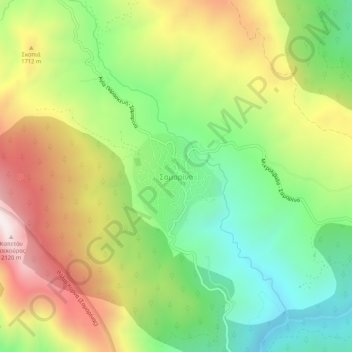
Naam: Topografische kaart Samarina, hoogte, reliëf.
Gemiddelde hoogte: 1.558 m
Minimale hoogte: 1.158 m
Maximale hoogte: 2.092 m
Samarina is located on an eastern spur of Mount Smolikas, the highest of the Pindus range and the second-highest mountain in all of Greece. At an altitude of 1380–1515 meters (4528' to 4970'), it is considered one of the highest villages in Greece and also one of the highest in the Balkans; its height puts it among soaring settlements such as: Aetomilitsa (Densko) and Seli (Selia).
Andere topografische kaarten
Klik op een kaart om zijn topografie, zijn hoogte en zijn reliëf te bekijken.
Δεσκάτη
Greece > Epirus and Western Macedonia > Grevena Regional Unit > Deskati Municipal Unit
Δεσκάτη, Deskati Municipal Unit, Deskati Municipality, Grevena Regional Unit, Western Macedonia, Epirus and Western Macedonia, 512 00, Greece
Gemiddelde hoogte: 952 m
Βατόλακκος
Greece > Epirus and Western Macedonia > Grevena Regional Unit
Βατόλακκος, Municipality of Grevena, Grevena Regional Unit, Western Macedonia, Epirus and Western Macedonia, 511 00, Greece
Gemiddelde hoogte: 584 m