
Topografische kaart Lake Livingston State Park
Interactieve kaart
Klik op de kaart om de hoogte weer te geven.
Over deze kaart
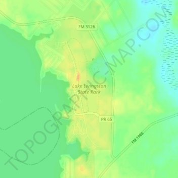
Naam: Topografische kaart Lake Livingston State Park, hoogte, reliëf.
Gemiddelde hoogte: 43 m
Minimale hoogte: 29 m
Maximale hoogte: 58 m
Andere topografische kaarten
Klik op een kaart om zijn topografie, zijn hoogte en zijn reliëf te bekijken.
Livingston
United States > Texas > Polk County
Livingston, Polk County, Texas, United States
Gemiddelde hoogte: 63 m
Lake Livingston
United States > Texas > Polk County
Lake Livingston, Polk County, Texas, United States
Gemiddelde hoogte: 66 m
Segno
United States > Texas > Polk County
Segno, Polk County, Texas, United States
Gemiddelde hoogte: 60 m
West Livingston
United States > Texas > Polk County
West Livingston, Polk County, Texas, 77351, United States
Gemiddelde hoogte: 42 m
Corrigan
United States > Texas > Polk County
Corrigan, Polk County, Texas, 75939, United States
Gemiddelde hoogte: 76 m
Tobacco Patch
United States > Texas > Polk County > Tobacco Patch
Tobacco Patch, Polk County, Texas, United States
Gemiddelde hoogte: 43 m
Asia
United States > Texas > Polk County > Asia
Asia, Polk County, Texas, 75939, United States
Gemiddelde hoogte: 80 m
Dallardsville
United States > Texas > Polk County > Dallardsville
Dallardsville, Polk County, Texas, 77332, United States
Gemiddelde hoogte: 76 m
Goodrich
United States > Texas > Polk County
Goodrich, Polk County, Texas, United States
Gemiddelde hoogte: 38 m
Seven Oaks
United States > Texas > Polk County
Seven Oaks, Polk County, Texas, United States
Gemiddelde hoogte: 68 m
Onalaska
United States > Texas > Polk County
Onalaska, Polk County, Texas, 77360, United States
Gemiddelde hoogte: 49 m
Blanchard
United States > Texas > Polk County
Blanchard, Polk County, Texas, United States
Gemiddelde hoogte: 47 m