
Topografische kaart Glebe
Interactieve kaart
Klik op de kaart om de hoogte weer te geven.
Over deze kaart
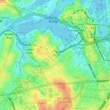
Naam: Topografische kaart Glebe, hoogte, reliëf.
Gemiddelde hoogte: 18 m
Minimale hoogte: -10 m
Maximale hoogte: 46 m
Andere topografische kaarten
Klik op een kaart om zijn topografie, zijn hoogte en zijn reliëf te bekijken.
Sydney
Australië > Nieuw-Zuid-Wales > Sydney
Sydney, Council of the City of Sydney, Nieuw-Zuid-Wales, 2000, Australië
Gemiddelde hoogte: 23 m
Echo Point
Australië > Nieuw-Zuid-Wales > Sydney > Katoomba
Echo Point, Katoomba, Sydney, Blue Mountains City Council, Nieuw-Zuid-Wales, 2780, Australië
Gemiddelde hoogte: 725 m
Barrenjoey Lighthouse
Australië > Nieuw-Zuid-Wales > Sydney
Barrenjoey Lighthouse, Smugglers Track, Palm Beach, Sydney, Northern Beaches Council, Northern Beaches, Nieuw-Zuid-Wales, 2108, Australië
Gemiddelde hoogte: 2 m
Manly
Australië > Nieuw-Zuid-Wales > Sydney
Manly, Sydney, Northern Beaches Council, Northern Beaches, Nieuw-Zuid-Wales, 2095, Australië
Gemiddelde hoogte: 13 m
Cowan Creek
Australië > Nieuw-Zuid-Wales > Sydney
Cowan Creek, Sydney, The Council of the Shire of Hornsby, Nieuw-Zuid-Wales, 2081, Australië
Gemiddelde hoogte: 98 m
Sydney Harbour National Park
Australië > Nieuw-Zuid-Wales > Sydney
Sydney Harbour National Park, Mosman, Sydney, Mosman Municipal Council, Lower North Shore, Nieuw-Zuid-Wales, 2088, Australië
Gemiddelde hoogte: 16 m
Darling Harbour
Australië > Nieuw-Zuid-Wales > Sydney
Darling Harbour, Sydney, Nieuw-Zuid-Wales, 2009, Australië
Gemiddelde hoogte: 23 m
Warriewood Beach
Australië > Nieuw-Zuid-Wales > Sydney > Mona Vale
Warriewood Beach, Mona Vale, Sydney, Northern Beaches Council, Northern Beaches, Nieuw-Zuid-Wales, 2103, Australië
Gemiddelde hoogte: 9 m
Berowra Valley National Park
Australië > Nieuw-Zuid-Wales > Sydney > Hornsby
Berowra Valley National Park, Sydney, Hornsby, The Council of the Shire of Hornsby, Nieuw-Zuid-Wales, Australië
Gemiddelde hoogte: 153 m
Ingleside
Australië > Nieuw-Zuid-Wales > Sydney
Ingleside, Sydney, Northern Beaches Council, Northern Beaches, Nieuw-Zuid-Wales, 2101, Australië
Gemiddelde hoogte: 105 m
Bilgola Beach
Australië > Nieuw-Zuid-Wales > Sydney
Bilgola Beach, Sydney, Northern Beaches Council, Northern Beaches, Nieuw-Zuid-Wales, 2107, Australië
Gemiddelde hoogte: 35 m
Turramurra
Australië > Nieuw-Zuid-Wales > Sydney
Turramurra, Sydney, Ku-ring-gai Council, Upper North Shore, Nieuw-Zuid-Wales, 2074, Australië
Gemiddelde hoogte: 144 m
Bondi Junction
Australië > Nieuw-Zuid-Wales > Sydney
Bondi Junction, Sydney, Waverley Council, Eastern Suburbs, Nieuw-Zuid-Wales, 2022, Australië
Gemiddelde hoogte: 63 m
Mona Vale
Australië > Nieuw-Zuid-Wales > Sydney > Mona Vale
Mona Vale, Sydney, Northern Beaches Council, Northern Beaches, Nieuw-Zuid-Wales, 2103, Australië
Gemiddelde hoogte: 20 m
Echo Point Park
Australië > Nieuw-Zuid-Wales > Sydney
Echo Point Park, Roseville Chase, Sydney, Ku-ring-gai Council, Upper North Shore, Nieuw-Zuid-Wales, 2069, Australië
Gemiddelde hoogte: 68 m
West Pennant Hills
Australië > Nieuw-Zuid-Wales > Sydney
West Pennant Hills, Sydney, The Hills Shire Council, Hills District, Nieuw-Zuid-Wales, 2125, Australië
Gemiddelde hoogte: 130 m
Palm Beach
Australië > Nieuw-Zuid-Wales > Sydney
Palm Beach, Sydney, Northern Beaches Council, Northern Beaches, Nieuw-Zuid-Wales, 2108, Australië
Gemiddelde hoogte: 13 m
Sydney Olympic Park
Australië > Nieuw-Zuid-Wales > Sydney
Sydney Olympic Park, Sydney, City of Parramatta Council, Nieuw-Zuid-Wales, 2127, Australië
Gemiddelde hoogte: 9 m
Katoomba
Australië > Nieuw-Zuid-Wales > Sydney > Katoomba
Katoomba, Sydney, Blue Mountains City Council, Nieuw-Zuid-Wales, 2780, Australië
Gemiddelde hoogte: 912 m
Terrey Hills
Australië > Nieuw-Zuid-Wales > Sydney
Terrey Hills, Sydney, Northern Beaches Council, Northern Beaches, Nieuw-Zuid-Wales, 2084, Australië
Gemiddelde hoogte: 146 m
Jamisons Lookout
Australië > Nieuw-Zuid-Wales > Sydney > Wentworth Falls
Jamisons Lookout, Sir H Burrell Drive, Wentworth Falls, Sydney, Blue Mountains City Council, Nieuw-Zuid-Wales, 2782, Australië
Gemiddelde hoogte: 767 m
Bondi Beach
Australië > Nieuw-Zuid-Wales > Sydney
Bondi Beach, Sydney, Waverley Council, Eastern Suburbs, Nieuw-Zuid-Wales, 2026, Australië
Gemiddelde hoogte: 31 m
Chatswood
Australië > Nieuw-Zuid-Wales > Sydney > Chatswood
Chatswood, Sydney, Willoughby City Council, Lower North Shore, Nieuw-Zuid-Wales, 2067, Australië
Gemiddelde hoogte: 81 m
Katoomba Falls Reserve
Australië > Nieuw-Zuid-Wales > Sydney > Katoomba
Katoomba Falls Reserve, Cliff Drive, Katoomba, Sydney, Blue Mountains City Council, Nieuw-Zuid-Wales, 2780, Australië
Gemiddelde hoogte: 857 m
Bronte Beach
Australië > Nieuw-Zuid-Wales > Sydney
Bronte Beach, Bronte, Sydney, Waverley Council, Eastern Suburbs, Nieuw-Zuid-Wales, 2024, Australië
Gemiddelde hoogte: 34 m
Ku-Ring_Gai Wildflower Garden
Australië > Nieuw-Zuid-Wales > Sydney
Ku-Ring_Gai Wildflower Garden, Warrimoo Avenue, St Ives Chase, Sydney, Ku-ring-gai Council, Upper North Shore, Nieuw-Zuid-Wales, 2075, Australië
Gemiddelde hoogte: 123 m
Wentworth Falls
Australië > Nieuw-Zuid-Wales > Sydney > Wentworth Falls
Wentworth Falls, Sydney, Blue Mountains City Council, Nieuw-Zuid-Wales, 2782, Australië
Gemiddelde hoogte: 708 m
Spooners Lookout
Australië > Nieuw-Zuid-Wales > Sydney > Katoomba
Spooners Lookout, Gathering Place, Katoomba, Sydney, Blue Mountains City Council, Nieuw-Zuid-Wales, 2780, Australië
Gemiddelde hoogte: 709 m
Ryde
Australië > Nieuw-Zuid-Wales > Sydney
Ryde, Sydney, Council of the City of Ryde, Nieuw-Zuid-Wales, 2112, Australië
Gemiddelde hoogte: 52 m
North Bondi
Australië > Nieuw-Zuid-Wales > Sydney
North Bondi, Sydney, Waverley Council, Nieuw-Zuid-Wales, 2026, Australië
Gemiddelde hoogte: 22 m
Baulkham Hills
Australië > Nieuw-Zuid-Wales > Sydney
Baulkham Hills, Sydney, The Hills, Nieuw-Zuid-Wales, 2153, Australië
Gemiddelde hoogte: 93 m
Churchill Road Reserve
Australië > Nieuw-Zuid-Wales > Sydney
Churchill Road Reserve, Leura, Sydney, Blue Mountains, Nieuw-Zuid-Wales, 2780, Australië
Gemiddelde hoogte: 933 m
Camperdown
Australië > Nieuw-Zuid-Wales > Sydney
Camperdown, Sydney, Nieuw-Zuid-Wales, 2050, Australië
Gemiddelde hoogte: 26 m