
Topografische kaart Katoomba Falls Reserve
Interactieve kaart
Klik op de kaart om de hoogte weer te geven.
Over deze kaart
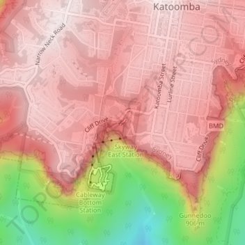
Naam: Topografische kaart Katoomba Falls Reserve, hoogte, reliëf.
Gemiddelde hoogte: 857 m
Minimale hoogte: 438 m
Maximale hoogte: 1.033 m
Andere topografische kaarten
Klik op een kaart om zijn topografie, zijn hoogte en zijn reliëf te bekijken.
Echo Point
Australië > Nieuw-Zuid-Wales > Sydney > Katoomba
Echo Point, Katoomba, Sydney, Blue Mountains City Council, Nieuw-Zuid-Wales, 2780, Australië
Gemiddelde hoogte: 725 m
Katoomba
Australië > Nieuw-Zuid-Wales > Sydney > Katoomba
Katoomba, Sydney, Blue Mountains City Council, Nieuw-Zuid-Wales, 2780, Australië
Gemiddelde hoogte: 912 m
Spooners Lookout
Australië > Nieuw-Zuid-Wales > Sydney > Katoomba
Spooners Lookout, Gathering Place, Katoomba, Sydney, Blue Mountains City Council, Nieuw-Zuid-Wales, 2780, Australië
Gemiddelde hoogte: 709 m